IMAGES TAKEN NEAR TO
Pant Lane, ABERGAVENNY, NP7 5DW
Introduction
This page details the photographs taken nearby to Pant Lane, NP7 5DW by members of the Geograph project.
The Geograph project started in 2005 with the aim of publishing, organising and preserving representative images for every square kilometre of Great Britain, Ireland and the Isle of Man.

There are currently over 7.5m images from over14,400 individuals and you can help contribute to the project by visiting https://www.geograph.org.uk
Image Map
Images are licensed for reuse under creativecommons.org/licenses/by-sa/2.0
Notes
- Clicking on the map will re-center to the selected point.
- The higher the marker number, the further away the image location is from the centre of the postcode.
Image Listing (503 Images Found)
Images are licensed for reuse under creativecommons.org/licenses/by-sa/2.0
Image
Details
Distance
1
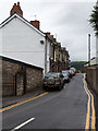
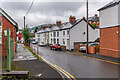
Pant Lane, Abergavenny
View north west up Pant Lane.
Image: © David P Howard
Taken: 2 Aug 2016
0.01 miles
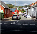
2
Pant Lane, Abergavenny
Viewed from Tudor Street. Pant is a frequently-seen element in Welsh place names and streets. It means a depression or hollow.
Image: © Jaggery
Taken: 14 Sep 2011
0.02 miles
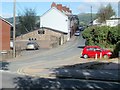
3
RAF Air Cadets recruiting trailer, Abergavenny
The trailer is parked near three wooden huts in a site on the corner of Pant Lane and Trinity Street. The two huts nearest the camera are the headquarters of 2478 (Abergavenny) ATC (Air Training Corps). The other hut is used by the Gwent Army Cadet Force.
The entrance to the site is from Trinity Street.
Image: © Jaggery
Taken: 14 Sep 2011
0.02 miles
4
Laundry Place houses and cars, Abergavenny
Looking north from the corner of Tudor Street.
Image: © Jaggery
Taken: 12 Nov 2023
0.02 miles
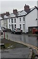
5
Laundry Place
Terrace of eight houses in a late 19th Century cul-de-sac off Tudor Street.
Image: © Ian Capper
Taken: 9 Sep 2021
0.02 miles
6
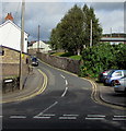
North along Pant Lane, Abergavenny
From Tudor Street. Meaning a depression or hollow, the Welsh word
Pant is a frequently-seen element in place and street names in Wales.
Image: © Jaggery
Taken: 30 Sep 2018
0.03 miles
7
Laundry Place, Abergavenny
Dead-end street on the north side of Tudor Street.
Image: © Jaggery
Taken: 30 Sep 2018
0.03 miles
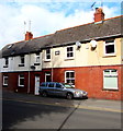
8
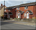
Brick semis, Tudor Street, Abergavenny
Semi-detached brick houses opposite Linda Vista Gardens.
Image: © Jaggery
Taken: 30 Sep 2018
0.04 miles
9
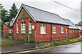
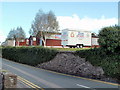
Tudor Street Day Centre
Day centre at the junction of Laundry Place and Tudor Street, the main part of which is a former technical school dating from before 1920.
Image: © Ian Capper
Taken: 9 Sep 2021
0.04 miles
10
Early 20th century houses, Tudor Street, Abergavenny
A tablet on a house wall shows the year 1914.
Image: © Jaggery
Taken: 30 Sep 2018
0.04 miles