IMAGES TAKEN NEAR TO
Victoria Street, ABERGAVENNY, NP7 5DT
Introduction
This page details the photographs taken nearby to Victoria Street, NP7 5DT by members of the Geograph project.
The Geograph project started in 2005 with the aim of publishing, organising and preserving representative images for every square kilometre of Great Britain, Ireland and the Isle of Man.

There are currently over 7.5m images from over14,400 individuals and you can help contribute to the project by visiting https://www.geograph.org.uk
Image Map
Images are licensed for reuse under creativecommons.org/licenses/by-sa/2.0
Notes
- Clicking on the map will re-center to the selected point.
- The higher the marker number, the further away the image location is from the centre of the postcode.
Image Listing (435 Images Found)
Images are licensed for reuse under creativecommons.org/licenses/by-sa/2.0
Image
Details
Distance
1
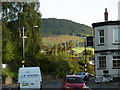
Views to the hills within Abergavenny
The view north towards Deri, the southeastern spur of Sugar Loaf, from Merthyr Road in the town reveals a 'welcome' in the hillsides, to quote an old saying.
Image: © Alan Bowring
Taken: 22 Sep 2016
0.02 miles
2
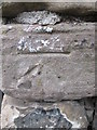
Ordnance Survey Cut Mark
This OS cut mark can be found at the junction of Pant Lane & Victoria Street. It marks a point 61.387m above mean sea level.
Image: © Adrian Dust
Taken: 4 Jun 2014
0.02 miles
3
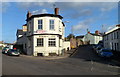
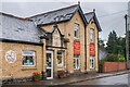
Somerset Arms, Abergavenny
Pub on the corner of Merthyr Road and Victoria Street.
Image: © Jaggery
Taken: 7 Dec 2011
0.03 miles
4
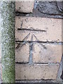
Ordnance Survey Cut Mark
This OS cut mark can be found on the old Salvation Army building, Sunnyside. It marks a point 57.507m above mean sea level.
Image: © Adrian Dust
Taken: 4 Jun 2014
0.03 miles
5
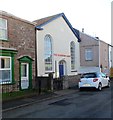
Salvation Army Hall, Victoria Street, Abergavenny
Located near the Regent Street junction. An inscription on a stone plaque above the windows records that this was originally Tabernacle Primitive Methodist Chapel, erected in 1850.
Image: © Jaggery
Taken: 7 Dec 2011
0.03 miles
6
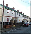
Victoria Street houses, Abergavenny
Looking west from near the corner of Regent Street.
Image: © Jaggery
Taken: 7 Dec 2011
0.03 miles
7
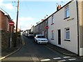
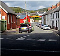
Prospect Road, Abergavenny
There is one-way traffic along narrow Prospect Road. Viewed from Pant Lane looking in the direction of Regent Street.
Image: © Jaggery
Taken: 7 Dec 2011
0.03 miles
8
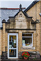
Former laundry
Entrance to the former laundry at 72 Merthyr Road, now housing a baby shop. The inscription in the gable reads "1887" (or is it 1897?), and "Abergavenny" - presumably with reference to the laundry erased from beneath. For a wider view, see Image
Image: © Ian Capper
Taken: 9 Sep 2021
0.04 miles
9
Former laundry
Former laundry at 72 Merthyr Road, now housing a baby shop and a carpet shop. For a close up of the gable above the door, see Image
Image: © Ian Capper
Taken: 9 Sep 2021
0.04 miles
10
Laundry Place, Abergavenny
Dead-end street on the north side of Tudor Street.
Image: © Jaggery
Taken: 30 Sep 2018
0.04 miles