IMAGES TAKEN NEAR TO
Tudor Street, ABERGAVENNY, NP7 5DL
Introduction
This page details the photographs taken nearby to Tudor Street, NP7 5DL by members of the Geograph project.
The Geograph project started in 2005 with the aim of publishing, organising and preserving representative images for every square kilometre of Great Britain, Ireland and the Isle of Man.

There are currently over 7.5m images from over14,400 individuals and you can help contribute to the project by visiting https://www.geograph.org.uk
Image Map
Images are licensed for reuse under creativecommons.org/licenses/by-sa/2.0
Notes
- Clicking on the map will re-center to the selected point.
- The higher the marker number, the further away the image location is from the centre of the postcode.
Image Listing (567 Images Found)
Images are licensed for reuse under creativecommons.org/licenses/by-sa/2.0
Image
Details
Distance
1
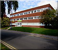
Jobcentre Plus, Tudor Street, Abergavenny
In three-storey Newbridge House on the corner of Baker Street.
Image: © Jaggery
Taken: 30 Sep 2018
0.01 miles
2
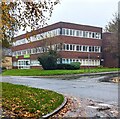
Abergavenny Jobcentre Plus
Viewed across Tudor Street in November 2023.
Image: © Jaggery
Taken: 12 Nov 2023
0.01 miles
3
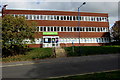
Steps up to Abergavenny Jobcentre Plus
From Tudor Street to three-storey Newbridge House.
Image: © Jaggery
Taken: 30 Sep 2018
0.01 miles
4
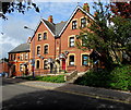
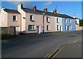
Tudor Street houses, Abergavenny
Located near the corner of Pant Lane, the houses are opposite Linda Vista Gardens.
Image: © Jaggery
Taken: 30 Sep 2018
0.02 miles
5
Baker Street houses, Abergavenny
The short row of houses is located between Tudor Street and Trinity Street.
Image: © Jaggery
Taken: 7 Dec 2011
0.02 miles
6
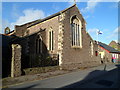
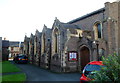
Grade II listed Church of the Holy Trinity, Abergavenny
This is the Baker Street side of the Church in Wales church, in the Diocese of Monmouth.
Holy Trinity Church was consecrated by the Bishop of Llandaff on November 6th 1840.
It was built as a chapel to serve the adjacent almshouses and the nearby school.
Grade II listed in 1974.
Image: © Jaggery
Taken: 7 Dec 2011
0.02 miles
7
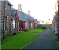
Grade II listed Trinity Almshouses, Abergavenny
This is one of two rows of almshouses inside the grounds of Holy Trinity church. http://www.geograph.org.uk/photo/2723503
This row is on the SW side of the church. The other row is parallel to it on the NE side of the church.
Grade II listed in January 1974.
Image: © Jaggery
Taken: 7 Dec 2011
0.02 miles
8
Eastern side of Grade II listed Church of the Holy Trinity, Abergavenny
A view of the church http://www.geograph.org.uk/photo/2723503 looking towards Baker Street.
Image: © Jaggery
Taken: 7 Dec 2011
0.02 miles
9
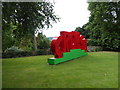
Wales National Eisteddfod sign in Abergavenny
Abergavenny proudly hosts the 2016 event - a rare and valuable coup for this massively anglicised south-eastern corner of Wales. Abergavenny is just 6 or so miles from the nearest point of the Wales-England border and the Welsh speaking population in these parts is amongst the lowest in all Wales. That situation is improving and this amazing event can only add impetus to that. The eisteddfod in turn is most welcome.
Image: © Jeremy Bolwell
Taken: 31 Jul 2016
0.03 miles
10
North along Pant Lane, Abergavenny
From Tudor Street. Meaning a depression or hollow, the Welsh word
Pant is a frequently-seen element in place and street names in Wales.
Image: © Jaggery
Taken: 30 Sep 2018
0.03 miles