IMAGES TAKEN NEAR TO
Merthyr Road, ABERGAVENNY, NP7 5DG
Introduction
This page details the photographs taken nearby to Merthyr Road, NP7 5DG by members of the Geograph project.
The Geograph project started in 2005 with the aim of publishing, organising and preserving representative images for every square kilometre of Great Britain, Ireland and the Isle of Man.

There are currently over 7.5m images from over14,400 individuals and you can help contribute to the project by visiting https://www.geograph.org.uk
Image Map
Images are licensed for reuse under creativecommons.org/licenses/by-sa/2.0
Notes
- Clicking on the map will re-center to the selected point.
- The higher the marker number, the further away the image location is from the centre of the postcode.
Image Listing (195 Images Found)
Images are licensed for reuse under creativecommons.org/licenses/by-sa/2.0
Image
Details
Distance
1
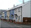
Blue and white new houses, Cae Pen y Dre, Abergavenny
Recently-built houses on a street named Cae Pen y Dre, viewed from the corner of Union Road East.
Image: © Jaggery
Taken: 22 Oct 2010
0.01 miles
2
Older houses, Cae Pen y Dre, Abergavenny
Cae Pen y Dre contains recently built houses http://www.geograph.org.uk/photo/2156865 and older ones, such as these, adjacent to a derelict chapel http://www.geograph.org.uk/photo/2156877 (just out of shot on the right).
Image: © Jaggery
Taken: 22 Oct 2010
0.01 miles
3
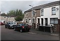
Row of houses, Cae Pen y Dre, Abergavenny
The road named Cae Pen y Dre is on the south side of Union Road East.
Image: © Jaggery
Taken: 30 Sep 2018
0.02 miles
4

Derelict former place of worship, Cae Pen y Dre, Abergavenny
The corrugated iron building appears long derelict in September 2018.
Coflein records that this was a Mission Hall, but does not state when the
building first opened for worship nor when it was abandoned.
Image: © Jaggery
Taken: 30 Sep 2018
0.03 miles
5
Castle Meadows at Abergavenny prepares for Wales National Eisteddfod
Taking shape.
Image: © Jeremy Bolwell
Taken: 17 Jul 2016
0.04 miles
6
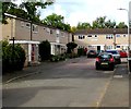
Western end of Cae Pen y Dre, Abergavenny
Connecting with Union Road East behind the camera, Cae Pen y Dre ends at
the edge of Cae Pen y Dre Close retirement housing in the background on the left.
Image: © Jaggery
Taken: 30 Sep 2018
0.04 miles
7
Cae Pen y Dre Close, Abergavenny
Cul-de-sac at the western end of Cae Pen y Dre, accessed by road from Union Road East.
Image: © Jaggery
Taken: 30 Sep 2018
0.05 miles
8
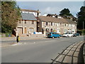
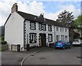
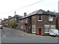
Abergavenny : Merthyr Road houses adjacent to north bank of the Usk
Houses located opposite a roundabout on Merthyr Road, about 100 metres north of the River Usk.
The house on the left was built (or possibly rebuilt) recently.
Image: © Jaggery
Taken: 22 Oct 2010
0.05 miles
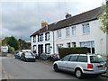
10
Union Street East, Abergavenny
Houses on the north side of the street, viewed from the corner of Merthyr Road and Tudor Street.
Image: © Jaggery
Taken: 22 Oct 2010
0.06 miles