IMAGES TAKEN NEAR TO
Merthyr Road, ABERGAVENNY, NP7 5DA
Introduction
This page details the photographs taken nearby to Merthyr Road, NP7 5DA by members of the Geograph project.
The Geograph project started in 2005 with the aim of publishing, organising and preserving representative images for every square kilometre of Great Britain, Ireland and the Isle of Man.

There are currently over 7.5m images from over14,400 individuals and you can help contribute to the project by visiting https://www.geograph.org.uk
Image Map
Images are licensed for reuse under creativecommons.org/licenses/by-sa/2.0
Notes
- Clicking on the map will re-center to the selected point.
- The higher the marker number, the further away the image location is from the centre of the postcode.
Image Listing (405 Images Found)
Images are licensed for reuse under creativecommons.org/licenses/by-sa/2.0
Image
Details
Distance
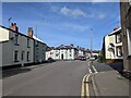
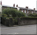
2

Corner of Merthyr Road and Brecon Road, Abergavenny
Detached house on the corner of Merthyr Road (on the left) and Brecon Road.
Image: © Jaggery
Taken: 22 Oct 2010
0.03 miles
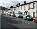
3
Southeast along Commercial Street, Abergavenny
Looking to the SE along Commercial Street from the corner of Brecon Road towards Merthyr Road.
The gap in the double yellow lines is at the St Helen's Road junction.
Image: © Jaggery
Taken: 30 Sep 2018
0.03 miles
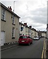
4
Merthyr Road houses, Abergavenny
Houses on the north side of Merthyr Road, between Brecon Road (behind the camera) and Commercial Street.
Image: © Jaggery
Taken: 22 Oct 2010
0.03 miles
5
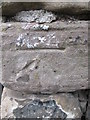
Ordnance Survey Cut Mark
This OS cut mark can be found at the junction of Pant Lane & Victoria Street. It marks a point 61.387m above mean sea level.
Image: © Adrian Dust
Taken: 4 Jun 2014
0.05 miles
6
Three Grade II listed houses above Merthyr Road, Abergavenny
Dating from c1840, Harwell House, Pembroke Villa and Pembroke Lodge are Grade II listed.
Image: © Jaggery
Taken: 30 Sep 2018
0.06 miles
8
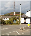
Rusting mast, Brecon Road, Abergavenny
Viewed from the corner of Merthyr Road. The mast is next to a boarded-up single storey building, formerly occupied by a plumbing and electrical business. The distances shown on the signs (in miles):
To the left, Brecon 20.
To the right, Monmouth 16, Hereford 22, Cwmbran 14, Newport 18.
Image: © Jaggery
Taken: 22 Oct 2010
0.06 miles
9
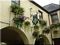
Brecon Road Dental Surgery, Abergavenny
Located at 34 Brecon Road, on the corner of Commercial Street. Viewed from Chapel Road.
Image: © Jaggery
Taken: 22 Oct 2010
0.07 miles
10
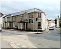
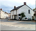
Railway Inn, Abergavenny
Pub located on the corner of Brecon Road and Commercial Street. The railway (and station) in question was nearby. Brecon Road railway station, which opened in 1862, closed in 1958.
A few metres away, on the other side of Brecon Road, is the Station Hotel. http://www.geograph.org.uk/photo/2129772
Image: © Jaggery
Taken: 22 Oct 2010
0.07 miles