IMAGES TAKEN NEAR TO
Regent Street, ABERGAVENNY, NP7 5BS
Introduction
This page details the photographs taken nearby to Regent Street, NP7 5BS by members of the Geograph project.
The Geograph project started in 2005 with the aim of publishing, organising and preserving representative images for every square kilometre of Great Britain, Ireland and the Isle of Man.

There are currently over 7.5m images from over14,400 individuals and you can help contribute to the project by visiting https://www.geograph.org.uk
Image Map
Images are licensed for reuse under creativecommons.org/licenses/by-sa/2.0
Notes
- Clicking on the map will re-center to the selected point.
- The higher the marker number, the further away the image location is from the centre of the postcode.
Image Listing (524 Images Found)
Images are licensed for reuse under creativecommons.org/licenses/by-sa/2.0
Image
Details
Distance
1
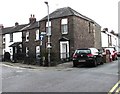
Junction of Princes Street and Regent Street, Abergavenny
Princes Street is on the left.
Image: © Jaggery
Taken: 30 Sep 2018
0.02 miles
2
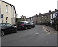
Western end of Princes Street, Abergavenny
One-way signs face Regent Street. Some references show Prince's Street
but there is no apostrophe on a nearby street name sign.
Image: © Jaggery
Taken: 30 Sep 2018
0.02 miles
3
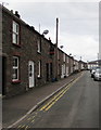
Princes Street towards Regent Street, Abergavenny
Looking to the NW past double yellow lines which indicate no parking on the left side of the street at any time.
Image: © Jaggery
Taken: 30 Sep 2018
0.02 miles
4
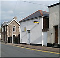
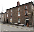
Gospel Hall, Regent Street, Abergavenny
The meeting house of the Plymouth Brethren. The building, constructed between 1834 and 1843, was originally the British School. It became a Gospel Hall in 1872 when the school moved to Victoria Street.
Image: © Jaggery
Taken: 22 Oct 2010
0.02 miles
5
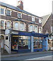
Two Frogmore Street businesses, Abergavenny
Venture4 Kitchens (bespoke kitchens, bathrooms and bedrooms) and The Barber Shop are located at the western end of Frogmore Street, a few metres from the War Memorial http://www.geograph.org.uk/photo/2130190 at the Park Road junction.
Image: © Jaggery
Taken: 7 Dec 2011
0.02 miles
6
One-way traffic along Princes Street, Abergavenny
Viewed from the corner of Regent Street.
Image: © Jaggery
Taken: 15 Jul 2012
0.03 miles
7
Three Grade II listed houses above Merthyr Road, Abergavenny
Dating from c1840, Harwell House, Pembroke Villa and Pembroke Lodge are Grade II listed.
Image: © Jaggery
Taken: 30 Sep 2018
0.03 miles
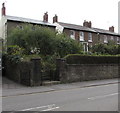
8
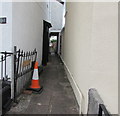
Albert Place, Abergavenny
Alley on the north side of Princes Street.
Image: © Jaggery
Taken: 30 Sep 2018
0.03 miles
9
Grade II listed pair of houses, Merthyr Road, Abergavenny
The Cadw website suggests that these houses probably date from c1830.
They are shown on the Tithe Map of 1844.
Image: © Jaggery
Taken: 30 Sep 2018
0.03 miles
10
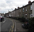
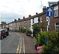
Houses alongside a bend in Princes Street Abergavenny
Some references show Prince's Street but there is no apostrophe on a nearby street name sign.
Image: © Jaggery
Taken: 30 Sep 2018
0.04 miles