IMAGES TAKEN NEAR TO
Malford Grove, ABERGAVENNY, NP7 0RN
Introduction
This page details the photographs taken nearby to Malford Grove, NP7 0RN by members of the Geograph project.
The Geograph project started in 2005 with the aim of publishing, organising and preserving representative images for every square kilometre of Great Britain, Ireland and the Isle of Man.

There are currently over 7.5m images from over14,400 individuals and you can help contribute to the project by visiting https://www.geograph.org.uk
Image Map
Images are licensed for reuse under creativecommons.org/licenses/by-sa/2.0
Notes
- Clicking on the map will re-center to the selected point.
- The higher the marker number, the further away the image location is from the centre of the postcode.
Image Listing (114 Images Found)
Images are licensed for reuse under creativecommons.org/licenses/by-sa/2.0
Image
Details
Distance
2
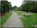
Picnic tables beside the canal at Gilwern
The adjacent car park also has the facilities for a picnic or barbecue. Here people stroll the canal towpath on a Sunday morning and a narrowboat heads towards Brecon.
Image: © Jeremy Bolwell
Taken: 22 Sep 2013
0.06 miles
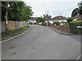
3
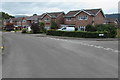
Malford Grove houses, Gilwern
Between Exford Grove (on the right) and Allerford Grove.
Image: © Jaggery
Taken: 20 Aug 2017
0.07 miles
4
Derelict lime kilns, Gilwern
Disused kilns and wharf opposite the Mon & Brec Canal car park.
Image: © M J Roscoe
Taken: 13 Jul 2019
0.07 miles
5
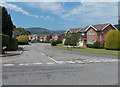
Malford Grove, Gilwern
Viewed across Church Road.
Image: © Jaggery
Taken: 7 Jun 2013
0.07 miles
6

Malford Grove houses, Gilwern
From the corner of Church Road. The name sign shows that Malford Grove is Llwyn Malford in Welsh.
Image: © Jaggery
Taken: 20 Aug 2017
0.07 miles
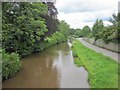
7
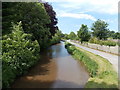
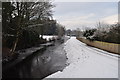
Canal NW of Church Road Gilwern
A view of the Monmouthshire & Brecon Canal.
Image: © Jaggery
Taken: 7 Jun 2013
0.08 miles
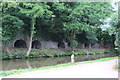
8
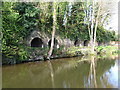
Lime kilns by the canal
A row of old lime kilns next to the Monmouthshire and Brecon Canal at Gilwern. These must have been fed by one or more of the many limestone quarries high on the hill to the west and may have reached here by one of the local tramways, before being roasted and transported by barge for agricultural fertiliser etc.
Image: © Gordon Hatton
Taken: 5 Apr 2017
0.08 miles
9
Hiley Avenue, Gilwern
The Oakdene Way http://www.geograph.org.uk/photo/5505949 junction is on the right.
A yellow Neighbourhood Watch Area notice is on the pole on the left.
Image: © Jaggery
Taken: 20 Aug 2017
0.09 miles
10
Monmouthshire & Brecon Canal, Gilwern (looking west)
Image: © Keith Salvesen
Taken: 24 Jun 2011
0.09 miles