IMAGES TAKEN NEAR TO
Waunavon, ABERGAVENNY, NP7 0PU
Introduction
This page details the photographs taken nearby to Waunavon, NP7 0PU by members of the Geograph project.
The Geograph project started in 2005 with the aim of publishing, organising and preserving representative images for every square kilometre of Great Britain, Ireland and the Isle of Man.

There are currently over 7.5m images from over14,400 individuals and you can help contribute to the project by visiting https://www.geograph.org.uk
Image Map
Images are licensed for reuse under creativecommons.org/licenses/by-sa/2.0
Notes
- Clicking on the map will re-center to the selected point.
- The higher the marker number, the further away the image location is from the centre of the postcode.
Image Listing (48 Images Found)
Images are licensed for reuse under creativecommons.org/licenses/by-sa/2.0
Image
Details
Distance
1
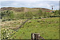
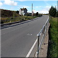
Rough grassland by minor road
Rough damp pasture next to minor road Image south of Blaenafon Road. The disused Cefn Garnyrerw Tip is in the background.
Image: © M J Roscoe
Taken: 30 May 2019
0.03 miles
2

Cascade from culvert below Blaenafon Road
The water in the drain flows into Coal Water Ponds by Llam-march Road.
Image: © M J Roscoe
Taken: 7 May 2023
0.06 miles
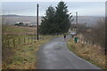
3
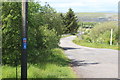
NCR 492 north from Blaenafon Road
The cycle route is on a minor road, once a railway track bed. Mynydd Llangatwg is in the background
Image: © M J Roscoe
Taken: 30 May 2019
0.07 miles
4
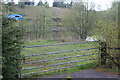
Roadside gate at upper pond, Coal Water Ponds
Pond Image below lane carrying NCR 492 and next to Llam-march Road.
Image: © M J Roscoe
Taken: 7 May 2023
0.07 miles
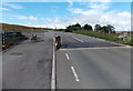
6
B4248 crosses a stream near Llanelly Hill
Railings on both sides of the road are at the edges of a bridge carrying the B4248
over a stream which flows north into the River Clydach, about 1.5km (nearly a mile) away.
Image: © Jaggery
Taken: 14 Sep 2013
0.07 miles
7
Runner on minor road off Blaenafon Road
The road is on the route of a dismantled railway and carries NCR 492. Mynydd Llangatwg is on the skyline.
Image: © M J Roscoe
Taken: 6 Jan 2023
0.07 miles
8
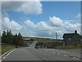
Cattle grid on B4248
Here the B4248 leaves open moor for a short distance around a cluster of houses and a junction with the road from Llanelly Hill
Image: © David Smith
Taken: 7 Jul 2011
0.07 miles
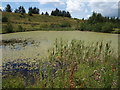
9
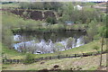
Upper Pond, Coal Water Ponds
One of two ponds with restricted access by Llam-March Road on site of former colliery.
Image: © M J Roscoe
Taken: 7 May 2023
0.07 miles
10
B4248 sheep grid and an open gate near Llanelly Hill
The grid is a barrier to the passage of hoofed animals such as cattle, sheep and horses. In this area it is mostly likely to function as a sheep grid. The side gate, on the side route to be used by horse riders and horse-drawn carriages, should be closed after use to prevent sheep etc. sneakily bypassing the grid.
Image: © Jaggery
Taken: 14 Sep 2013
0.07 miles