IMAGES TAKEN NEAR TO
Waenllapria, ABERGAVENNY, NP7 0PT
Introduction
This page details the photographs taken nearby to Waenllapria, NP7 0PT by members of the Geograph project.
The Geograph project started in 2005 with the aim of publishing, organising and preserving representative images for every square kilometre of Great Britain, Ireland and the Isle of Man.

There are currently over 7.5m images from over14,400 individuals and you can help contribute to the project by visiting https://www.geograph.org.uk
Image Map
Images are licensed for reuse under creativecommons.org/licenses/by-sa/2.0
Notes
- Clicking on the map will re-center to the selected point.
- The higher the marker number, the further away the image location is from the centre of the postcode.
Image Listing (11 Images Found)
Images are licensed for reuse under creativecommons.org/licenses/by-sa/2.0
Image
Details
Distance
2
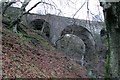
Viaduct Near Llanelli Hill
Magnificent Arch Viaduct on Abergavenny to Brynmawr disused rail line.
Image: © RAY JONES
Taken: 6 Jan 2004
0.12 miles
4
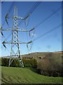
Llanelly Hill
A giant electricity pylon.
Image: © Burgess Von Thunen
Taken: 6 Feb 2013
0.13 miles
6
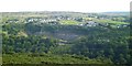
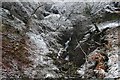
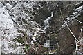
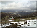
Across the Clydach Gorge from Darren Ddu
The view south from near the old tramway on the north side of Clydach gorge. Out of sight down below is the busy Heads of the Valleys road, whilst on the other side is an old limestone quarry with the village of Llanelly Hill above it.
Image: © Gordon Hatton
Taken: 4 Sep 2013
0.19 miles
10
Looking towards Sugar Loaf from Llanelly Hill
Image: © andy dolman
Taken: 3 Jan 2000
0.23 miles