1
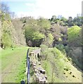
Eastern portals of Gelli-Felen tunnel
The southern of the former railway tunnels is blocked, whereas the northern one is not. The cyclepath swings to the right, following the route of Bailey's 1821 tramroad.
Image: © Gareth James
Taken: 15 Oct 2011
0.13 miles
2
Site of Clydach station, 1988
View SW, towards Brynmawr and Merthyr: ex-LNWR Abergavenny Junction - Brynmawr - Merthyr line, the celebrated Heads of Valleys line, all closed 6/1/58. (See also
Image]).
Image: © Ben Brooksbank
Taken: 8 May 1988
0.14 miles
3
Old railway trackbed, Clydach Gorge
The entrance portals to Gellifelen tunnel are just visible, the lefthand one is bricked up.
Image: © Flying Stag
Taken: 12 May 2012
0.14 miles
4
Llanelly Hill
Image: © andy dolman
Taken: 10 Sep 2008
0.17 miles
5
Cyclepath in Clydach Gorge
National Cycle Network Route 46 on the formation of the Merthyr, Tredegar and Abergavenny Railway, at this point running on a ledge above Glydach Gorge; the eastern portals of Gelli-Felen tunnel can be seen in the distance.
Over this section, the cycle route is not tarmaced, in contrast to most of the rest of the route.
Image: © Gareth James
Taken: 15 Oct 2011
0.18 miles
6
Ledge for former railway in Clydach Gorge
Image: © Gareth James
Taken: 15 Oct 2011
0.19 miles
7
NCN Route 46 in Clydach Gorge
Here, the cycle path takes the route of Bailey's tramroad, avoiding the later-built Gelli-Felen tunnels.
Image: © Gareth James
Taken: 15 Oct 2011
0.20 miles
8
Clydach Gorge railway
When completed NCN46 will follow the course of the old railway down the gorge, offering some spectacular views of natural and manmade landscapes.
Image: © Alan Bowring
Taken: 21 Apr 2007
0.21 miles
9
Old railway tunnels at Gellifelin in the Clydach Gorge
Sadly by-passed by the national cycleroute and footpath but hardly visitor proof. The railway here was the defunct Merthyr, Tredegar & Abergavenny Railway which ran up this gorge between 1862 and 1958. Just one of several amazing early engineering feats accomplished to enable the railway to run here.
Image: © Jeremy Bolwell
Taken: 3 Nov 2012
0.24 miles
10
View across the Clydach Gorge
The newly developed National Cycleway route follows the former rail line which runs across the far slope. An extraordinarily interesting area where man and nature, beauty and despoliation lie cheek by jowl.
Image: © Alan Bowring
Taken: 23 Jun 2007
0.24 miles


