IMAGES TAKEN NEAR TO
The Crossing, ABERGAVENNY, NP7 0NL
Introduction
This page details the photographs taken nearby to The Crossing, NP7 0NL by members of the Geograph project.
The Geograph project started in 2005 with the aim of publishing, organising and preserving representative images for every square kilometre of Great Britain, Ireland and the Isle of Man.

There are currently over 7.5m images from over14,400 individuals and you can help contribute to the project by visiting https://www.geograph.org.uk
Image Map
Images are licensed for reuse under creativecommons.org/licenses/by-sa/2.0
Notes
- Clicking on the map will re-center to the selected point.
- The higher the marker number, the further away the image location is from the centre of the postcode.
Image Listing (39 Images Found)
Images are licensed for reuse under creativecommons.org/licenses/by-sa/2.0
Image
Details
Distance
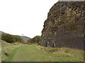
1
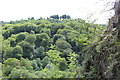
Cwm Clydach National Nature Reserve
Looking across Cwm Clydach from the top of Blackrock old limekilns. The houses almost on the skyline are near Darrenfelen.
Image: © M J Roscoe
Taken: 12 Jul 2016
0.11 miles
3
Looking towards Sugar Loaf from Llanelly Hill
Image: © andy dolman
Taken: 3 Jan 2000
0.13 miles
4
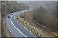
A465 Heads of the Valleys Road, near Blackrock, March 2016
Traffic management for construction work for converting the A465 to a dual carriageway; viewed from the adjacent higher Main Road.
Image: © M J Roscoe
Taken: 8 Mar 2016
0.13 miles
5
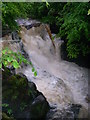
Afon Clydach: Rhaeadr Isaf
One of several waterfalls over which the Afon Clydach plunges as it drops 1000ft/300m from Brynmawr down the gorge to join the Wysg/Usk below Gilwern. Much of the gorge is still cloaked in beech trees making it the most westerly natural beechwood in the country and hence also a national nature reserve.
Image: © Alan Bowring
Taken: 13 May 2007
0.14 miles
6
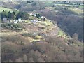
Across the Clydach gorge
Somewhere down below traffic roars past on the A465 Heads of the Valleys Road, but the view here is of scattered dwellings, exposed limestone and the line of an old railway, with tunnel portals visible to the right, about halfway up the picture. There's a lot to see in views of this area.
Image: © Gordon Hatton
Taken: 17 Apr 2015
0.14 miles
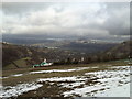
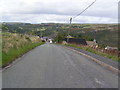
7
High ground SE of Main Road Blackrock
Looking towards the high ground south of the A465 Heads of the Valleys Road.
Image: © Jaggery
Taken: 7 Jun 2013
0.15 miles
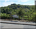
9
Former railway route in Clydach Gorge
Now part of National Cycle Network route 46, un-tarmaced over this small section.
Image: © Gareth James
Taken: 15 Oct 2011
0.15 miles
10
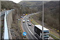
A465, Heads of the Valleys Road near Clydach, March 2017
Traffic management for major road improvement of the A465; for scene a year ago, see Image the road on the left is Main Road; the woodland on the right is part of the Cwm Clydach National Nature Reserve.
Image: © M J Roscoe
Taken: 7 Mar 2017
0.16 miles