IMAGES TAKEN NEAR TO
Clydach, ABERGAVENNY, NP7 0LN
Introduction
This page details the photographs taken nearby to NP7 0LN by members of the Geograph project.
The Geograph project started in 2005 with the aim of publishing, organising and preserving representative images for every square kilometre of Great Britain, Ireland and the Isle of Man.

There are currently over 7.5m images from over14,400 individuals and you can help contribute to the project by visiting https://www.geograph.org.uk
Image Map
Images are licensed for reuse under creativecommons.org/licenses/by-sa/2.0
Notes
- Clicking on the map will re-center to the selected point.
- The higher the marker number, the further away the image location is from the centre of the postcode.
Image Listing (29 Images Found)
Images are licensed for reuse under creativecommons.org/licenses/by-sa/2.0
Image
Details
Distance
2
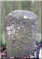
Milestone - Abergavenny 6
Inscription reads:-
Abergavenny / 6
Milestone Society National ID: BRE_AGMY06
Image: © Adrian Dust
Taken: 29 Nov 2020
0.04 miles
4
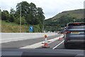
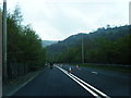
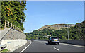
Queue of traffic in roadworks, A465
Converting the Heads of the Valley Road to dual carriage way causes delays. Gilwern Hill is to the right. The Escape Lane sign probably relates to the old road.
Image: © M J Roscoe
Taken: 10 Jul 2020
0.05 miles
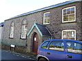
7
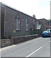
Wesleyan Chapel Clydach
The Main Road chapel is a 1902 rebuild of the 1829 original.
Among its secular uses is as a polling station on election days.
Image: © Jaggery
Taken: 7 Jun 2013
0.09 miles
8
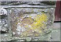
Ordnance Survey Cut Mark
This very eroded OS cut mark can be found on the porch of the Chapel. It marks a point 208.189m above mean sea level.
Image: © Adrian Dust
Taken: 29 Nov 2020
0.10 miles
9
Old chapel and Sunday school, Clydach Gorge
The plaque mentions an early date for the Wesleyan Methodist chapel of 1829 and the extension added for the schoolroom adjacent is dated 1902.
Image: © Jeremy Bolwell
Taken: 3 Nov 2012
0.10 miles
10
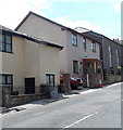
Unusual use for a dustbin, Clydach
Filling with earth for stability, an old dustbin is in use alongside Main Road as an improvised
30mph speed limit sign. Wesleyan Chapel http://www.geograph.org.uk/photo/3508078 is in the background.
Image: © Jaggery
Taken: 7 Jun 2013
0.10 miles