IMAGES TAKEN NEAR TO
Clydach, ABERGAVENNY, NP7 0LF
Introduction
This page details the photographs taken nearby to NP7 0LF by members of the Geograph project.
The Geograph project started in 2005 with the aim of publishing, organising and preserving representative images for every square kilometre of Great Britain, Ireland and the Isle of Man.

There are currently over 7.5m images from over14,400 individuals and you can help contribute to the project by visiting https://www.geograph.org.uk
Image Map
Images are licensed for reuse under creativecommons.org/licenses/by-sa/2.0
Notes
- Clicking on the map will re-center to the selected point.
- The higher the marker number, the further away the image location is from the centre of the postcode.
Image Listing (31 Images Found)
Images are licensed for reuse under creativecommons.org/licenses/by-sa/2.0
Image
Details
Distance
1
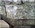
Ordnance Survey Cut Mark
This OS cut mark can be found on the wall west side of the road. It marks a point 153.846m above mean sea level.
Image: © Adrian Dust
Taken: 29 Nov 2020
0.02 miles
3
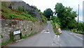
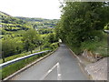
Church Road and the Old Main Road
Within earshot of the busy A465 Heads of the Valleys Road in the Clydach valley.
Church Road eventually leads north to Llanelly.
Image: © Jonathan Billinger
Taken: 10 Jun 2016
0.03 miles
4
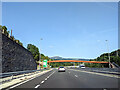
Junction on the A465 and rust finished footbridge
Image: © Rob Purvis
Taken: 14 Sep 2022
0.03 miles
5
From Church Road to Main Road, Clydach
Church Road is behind the camera. The road ahead descends towards Main Road.
Image: © Jaggery
Taken: 7 Jun 2013
0.07 miles
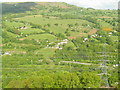
7
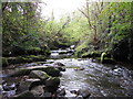
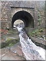
A meeting of waters
The Nant Dyar completes its short but steep journey from the Canada Tips down Cwm Dyar to join with the more voluminous waters of the Clydach, it too having bade farewell to the Coal Measures rocks near its source, plunged down through the Carboniferous gritstone and limestone and cut a gorge into the underlying brown Devonian sandstones.
Image: © Alan Bowring
Taken: 19 Jan 2014
0.08 miles
8
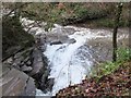
River Clydach below Pant-glas Bridge
Image: © Keith Salvesen
Taken: 24 Jun 2011
0.09 miles
9
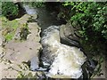
Bridge over the Nant Dyar
Station Road gives access to the communities which cling to the steep hillsides on the southern side of the gorge. Here it crosses the Nant Dyar which rushes across slabs of Old Red Sandstone hastening to its confluence with the Clydach a few tens of yards downstream.
Image: © Alan Bowring
Taken: 19 Jan 2014
0.10 miles
10
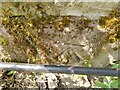
Ordnance Survey Cut Mark
This OS cut mark can be found on the SW parapet of the bridge. It marks a point 140.004m above mean sea level.
Image: © Adrian Dust
Taken: 9 Jun 2023
0.10 miles