IMAGES TAKEN NEAR TO
Maes Y Gwartha Road, ABERGAVENNY, NP7 0EY
Introduction
This page details the photographs taken nearby to Maes Y Gwartha Road, NP7 0EY by members of the Geograph project.
The Geograph project started in 2005 with the aim of publishing, organising and preserving representative images for every square kilometre of Great Britain, Ireland and the Isle of Man.

There are currently over 7.5m images from over14,400 individuals and you can help contribute to the project by visiting https://www.geograph.org.uk
Image Map
Images are licensed for reuse under creativecommons.org/licenses/by-sa/2.0
Notes
- Clicking on the map will re-center to the selected point.
- The higher the marker number, the further away the image location is from the centre of the postcode.
Image Listing (20 Images Found)
Images are licensed for reuse under creativecommons.org/licenses/by-sa/2.0
Image
Details
Distance
1
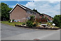
Old Rectory Close, Maesygwartha
This is the southern edge of Old Rectory Close, viewed from the main road through the village.
Image: © Jaggery
Taken: 7 Jun 2013
0.02 miles
2
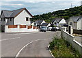
Beaconsfield Maesygwartha
Beaconsfield is a residential cul-de-sac on the south side of the main road
through Maesygwartha, a small village in Monmouthshire, near Gilwern.
Image: © Jaggery
Taken: 7 Jun 2013
0.07 miles
3
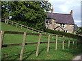
Maesygwartha House, Maesygwartha
Viewed from the public footpath which crosses the driveway on its way to Llanelly.
Image: © John Brightley
Taken: 22 Oct 2010
0.08 miles
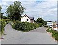
4
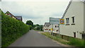
New housing, Maesygwartha
Maesygwartha Road leads to Gilwern.
Image: © Jonathan Billinger
Taken: 10 Jun 2016
0.09 miles
5
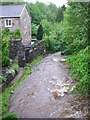
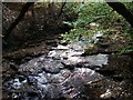
Afon Clydach
A rain-swollen Afon Clydach rushes past the old Forge House at Maesygwartha towards the bottom of the Clydach Gorge.
Image: © Alan Bowring
Taken: 13 May 2007
0.10 miles
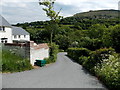
6
Western boundary of Maesygwartha
The old road from Brynmawr to Gilwern reaches Maesygwartha, a small village in Monmouthshire.
Image: © Jaggery
Taken: 7 Jun 2013
0.11 miles
8
Unnamed road from Maesygwartha to the A465 Heads of the Valleys road
Viewed from near the western boundary sign http://www.geograph.org.uk/photo/3508428 for Maesygwartha.
Image: © Jaggery
Taken: 7 Jun 2013
0.12 miles
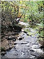
9
River Clydach at Maesygwartha
I was surprised that nobody else had submitted photos of this photogenic spot.
Image: © John Brightley
Taken: 22 Oct 2010
0.12 miles
10
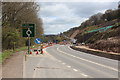
Diversion, Heads of the Valleys Road, Gilwern
Minor deviation on the A465 for a temporary roundabout near Gilwern during construction of a new carriageway on the hillside, right.
Image: © M J Roscoe
Taken: 10 Apr 2017
0.12 miles