IMAGES TAKEN NEAR TO
Bank Crescent, ABERGAVENNY, NP7 0DL
Introduction
This page details the photographs taken nearby to Bank Crescent, NP7 0DL by members of the Geograph project.
The Geograph project started in 2005 with the aim of publishing, organising and preserving representative images for every square kilometre of Great Britain, Ireland and the Isle of Man.

There are currently over 7.5m images from over14,400 individuals and you can help contribute to the project by visiting https://www.geograph.org.uk
Image Map
Images are licensed for reuse under creativecommons.org/licenses/by-sa/2.0
Notes
- Clicking on the map will re-center to the selected point.
- The higher the marker number, the further away the image location is from the centre of the postcode.
Image Listing (118 Images Found)
Images are licensed for reuse under creativecommons.org/licenses/by-sa/2.0
Image
Details
Distance
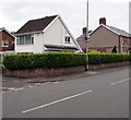
1
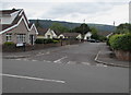
Bank Crescent, Gilwern
Cul-de-sac viewed across the A4077 Crickhowell Road.
Image: © Jaggery
Taken: 20 Aug 2017
0.02 miles
2
Crickhowell Road houses, Gilwern
Viewed across the A4077 Crickhowell Road from the corner of Hiley Avenue.
Image: © Jaggery
Taken: 20 Aug 2017
0.03 miles
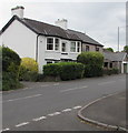
3
Cartref, Gilwern
Viewed across the A4077 Crickhowell Road. Cartref and its neighbour
on the left are houses near the northwest edge of Gilwern.
Image: © Jaggery
Taken: 20 Aug 2017
0.03 miles
4
Crickhowell Road houses, Gilwern
The corner of Bank Crescent http://www.geograph.org.uk/photo/5504823 is on the right.
Image: © Jaggery
Taken: 20 Aug 2017
0.03 miles
5
Speed camera warning sign, Crickhowell Road, Gilwern
The sign is on a Crickhowell Road lamppost near the corner of Bank Crescent.
The speed limit on the A4077 Crickhowell Road dropped from the National Speed Limit
to 30mph a few tens of metres behind the camera, at the northwest edge of the village.
Image: © Jaggery
Taken: 20 Aug 2017
0.04 miles
6

Bilingual name sign on a Gilwern corner
The sign near the A4077 Crickhowell Road shows that the Welsh versions of
HILEY AVENUE and OAKDENE WAY are RHODFA HILEY and FFORDD OAKDENE.
Image: © Jaggery
Taken: 20 Aug 2017
0.04 miles
7
Crickhowell Road semis, Gilwern
Semi-detached houses on the east side of Crickhowell Road
between the Bank Crescent junction and the Glangrwyney Road junction.
Image: © Jaggery
Taken: 20 Aug 2017
0.04 miles
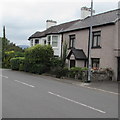
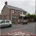
8
White house, Crickhowell Road, Gilwern
The house is named Athrofa, Welsh for a place of learning such as a college, academy or institute of education.
A former school is on the right. http://www.geograph.org.uk/photo/5508333
Image: © Jaggery
Taken: 20 Aug 2017
0.06 miles
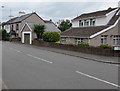
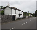
10
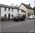
Penybont Cottage, Crickhowell Road, Gilwern
Penybont Cottage on the left, Corn Exchange pub http://www.geograph.org.uk/photo/5508327 on the right.
Image: © Jaggery
Taken: 20 Aug 2017
0.06 miles