IMAGES TAKEN NEAR TO
Dan Y Bont, ABERGAVENNY, NP7 0DD
Introduction
This page details the photographs taken nearby to Dan Y Bont, NP7 0DD by members of the Geograph project.
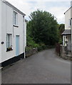
The Geograph project started in 2005 with the aim of publishing, organising and preserving representative images for every square kilometre of Great Britain, Ireland and the Isle of Man.

There are currently over 7.5m images from over14,400 individuals and you can help contribute to the project by visiting https://www.geograph.org.uk
Image Map
Images are licensed for reuse under creativecommons.org/licenses/by-sa/2.0
Notes
- Clicking on the map will re-center to the selected point.
- The higher the marker number, the further away the image location is from the centre of the postcode.
Image Listing (216 Images Found)
Images are licensed for reuse under creativecommons.org/licenses/by-sa/2.0
Image
Details
Distance
1
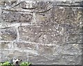
Ordnance Survey Cut Mark
This OS cut mark can be found on the NE parapet of the bridge over the River Clydach. It marks a point 125.695m above mean sea level.
Image: © Adrian Dust
Taken: 6 Jul 2020
0.04 miles
2
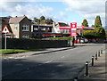
Murco and Spar, Gilwern
Located on Crickhowell Road, between Dan-y-Bont and Church Road. You pay for your Murco petrol in the Spar shop.
Image: © Jaggery
Taken: 20 Oct 2010
0.04 miles
3
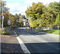
Weak bridge ahead, Crickhowell Road, Gilwern
Viewed from the corner of Back Road. A sign warns that the bridge ahead has a weight limit of 7.5 tonnes. The bridge carries Crickhowell Road above the River Clydach, at this point about a kilometre from its confluence with the Usk.
Image: © Jaggery
Taken: 20 Oct 2010
0.04 miles
4
Pen-y-bont Terrace, Gilwern
Ascending from the corner of Church Road.
Image: © Jaggery
Taken: 20 Aug 2017
0.04 miles
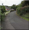
5
Back Road, Gilwern
Along Back Road from the corner of Main Road towards Crickhowell Road. Beech Cottage http://www.geograph.org.uk/photo/5496576 is on the left.
Image: © Jaggery
Taken: 13 Aug 2017
0.06 miles
6
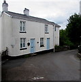
Beech Cottage, Back Road, Gilwern
Viewed from the corner of Main Road.
Image: © Jaggery
Taken: 13 Aug 2017
0.06 miles
7
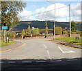
Common Road, Gilwern
Common Road heads away from Crickhowell Road. Despite its name, and the many village commons still existing, there is only one other Common Road in SE Wales, (Pontypridd), though there are many in England.
Image: © Jaggery
Taken: 20 Oct 2010
0.06 miles
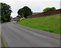
8
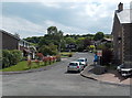
Forest Hill, Gilwern
Forest Hill is a cul-de-sac on the south side of Church Road.
Image: © Jaggery
Taken: 7 Jun 2013
0.06 miles
9
Wooden fence on top of a grassy bank, Church Road, Gilwern
The fence is at the edge of rear gardens of houses on the south side of Exford Grove.
Image: © Jaggery
Taken: 20 Aug 2017
0.06 miles
10

Church Road telecoms cabinets, Gilwern
Viewed from the corner of Forest Hill.
Image: © Jaggery
Taken: 20 Aug 2017
0.06 miles