IMAGES TAKEN NEAR TO
Back Road, ABERGAVENNY, NP7 0DA
Introduction
This page details the photographs taken nearby to Back Road, NP7 0DA by members of the Geograph project.
The Geograph project started in 2005 with the aim of publishing, organising and preserving representative images for every square kilometre of Great Britain, Ireland and the Isle of Man.

There are currently over 7.5m images from over14,400 individuals and you can help contribute to the project by visiting https://www.geograph.org.uk
Image Map
Images are licensed for reuse under creativecommons.org/licenses/by-sa/2.0
Notes
- Clicking on the map will re-center to the selected point.
- The higher the marker number, the further away the image location is from the centre of the postcode.
Image Listing (213 Images Found)
Images are licensed for reuse under creativecommons.org/licenses/by-sa/2.0
Image
Details
Distance
1
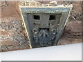
Ordnance Survey Flush Bracket S1024
This can be found on the roadside wall of Gilwern United Reformed Church.
For more detail see : http://www.bench-marks.org.uk/bm11837
Image: © Peter Wood
Taken: 21 Oct 2016
0.01 miles
2
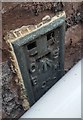
Ordnance Survey Flush Bracket (S1024)
This OS Flush Bracket can be found on the east angle of the chapel. It marks a point 109.608m above mean sea level.
Image: © Adrian Dust
Taken: 6 Jul 2020
0.02 miles
3
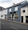
Bromfields Family Butchers shop in Gilwern
At 40 Main Road.
Image: © Jaggery
Taken: 13 Aug 2017
0.02 miles
4
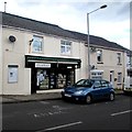
John Williams Pharmacy, Gilwern
Pharmacy at 36 Main Road.
Image: © Jaggery
Taken: 13 Aug 2017
0.02 miles
5
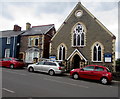
Gilwern United Reformed Church
At 40 Main Road in Gilwern, opposite School Lane. The church opened in 1886 as Gilwern Congregational Church. The church was renamed in 1972 when the Congregational Church in England and Wales merged with the Presbyterian Church of England to form the United Reformed Church.
Image: © Jaggery
Taken: 13 Aug 2017
0.02 miles
6
Main Road houses, Gilwern
Between Back Road on the left and Gilwern United Reformed Church. http://www.geograph.org.uk/photo/5496614
Image: © Jaggery
Taken: 13 Aug 2017
0.02 miles
7
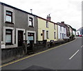
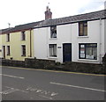
Row of houses, Main Road, Gilwern
On the south side of the A4077 Main Road. Number 38 Main Road is on the left.
The house at the right edge of the row is on the corner of School Lane.
Double yellow lines indicate no parking at any time on this side of the road.
Image: © Jaggery
Taken: 13 Aug 2017
0.02 miles
8
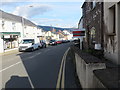
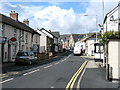
Main Road in Gilwern
Looking north-eastward.
Image: © Peter Wood
Taken: 21 Oct 2016
0.03 miles
9
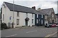
Woodbine Cottage, Main Road, Gilwern
Viewed on August 13th 2017. A notice in the window on the right states that DynIT (Home & Business IT Support) will be closing its doors on August 17th 2017. There are no current plans for reopening.
Image: © Jaggery
Taken: 13 Aug 2017
0.03 miles