IMAGES TAKEN NEAR TO
Brynglas, ABERGAVENNY, NP7 0BN
Introduction
This page details the photographs taken nearby to Brynglas, NP7 0BN by members of the Geograph project.
The Geograph project started in 2005 with the aim of publishing, organising and preserving representative images for every square kilometre of Great Britain, Ireland and the Isle of Man.

There are currently over 7.5m images from over14,400 individuals and you can help contribute to the project by visiting https://www.geograph.org.uk
Image Map
Images are licensed for reuse under creativecommons.org/licenses/by-sa/2.0
Notes
- Clicking on the map will re-center to the selected point.
- The higher the marker number, the further away the image location is from the centre of the postcode.
Image Listing (170 Images Found)
Images are licensed for reuse under creativecommons.org/licenses/by-sa/2.0
Image
Details
Distance
1
Common Road houses, Gilwern
On the west side of the road.
Image: © Jaggery
Taken: 13 Aug 2017
0.04 miles
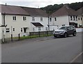
2
Brynglas, Gilwern
From Common Road, Brynglas leads to Dan-y-bryn.
Image: © Jaggery
Taken: 13 Aug 2017
0.06 miles
3
No longer a phonebox, Common Road, Gilwern
The phoneless doorless former phonebox is in a hedge near the corner of Brynglas. Viewed in August 2017.
Image: © Jaggery
Taken: 13 Aug 2017
0.06 miles
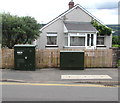
4
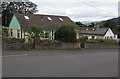
Common Road bungalows, Gilwern
Originally, bungalow was used in English for a lightly-built house, with a veranda and one storey.
In current UK usage it is a convenient word for any one-storey dwelling.
Image: © Jaggery
Taken: 13 Aug 2017
0.07 miles
5
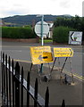
Green Man direction sign, Crickhowell Road, Gilwern
The Welsh/English temporary sign is in place on Sunday August 13th 2017.
This year the Green Man music and arts festival in the Brecon Beacons is from August 17th-20th.
Image: © Jaggery
Taken: 13 Aug 2017
0.07 miles
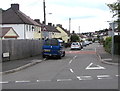
6
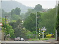
Crickhowell Road, Gilwern, Monmouthshire
Image: © Jeff Gogarty
Taken: 28 May 2016
0.07 miles
7
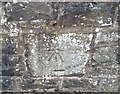
Ordnance Survey Cut Mark
This OS cut mark can be found on the wall at the rear of the Beaufort Arms. It marks a point 102.308m above mean sea level.
Image: © Adrian Dust
Taken: 6 Jul 2020
0.08 miles
8
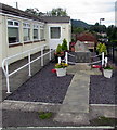
Gilwern War Memorial
The War Memorial and Garden of Remembrance are at the edge of the village hall, on the right here. http://www.geograph.org.uk/photo/5521032
Image: © Jaggery
Taken: 13 Aug 2017
0.08 miles
9
Two telecoms cabinets, Crickhowell Road, Gilwern
BT cabinet on the left, Virgin Media cabinet on the right.
Image: © Jaggery
Taken: 13 Aug 2017
0.08 miles
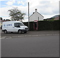
10
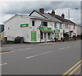
Londis Gilwern
Convenience store at 18–20 Main Road, Gilwern.
Image: © Jaggery
Taken: 13 Aug 2017
0.08 miles