IMAGES TAKEN NEAR TO
NP6 1NS
Introduction
This page details the photographs taken nearby to NP6 1NS by members of the Geograph project.
The Geograph project started in 2005 with the aim of publishing, organising and preserving representative images for every square kilometre of Great Britain, Ireland and the Isle of Man.

There are currently over 7.5m images from over14,400 individuals and you can help contribute to the project by visiting https://www.geograph.org.uk
Image Map
Images are licensed for reuse under creativecommons.org/licenses/by-sa/2.0
Notes
- Clicking on the map will re-center to the selected point.
- The higher the marker number, the further away the image location is from the centre of the postcode.
Image Listing (312 Images Found)
Images are licensed for reuse under creativecommons.org/licenses/by-sa/2.0
Image
Details
Distance
1
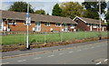
Isca Court Bungalows, Caerleon
Sheltered housing, managed by Newport City Homes, located on the west side of College Crescent.
Image: © Jaggery
Taken: 27 Aug 2009
0.00 miles
3
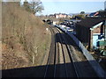
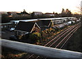
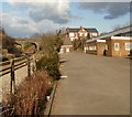
Welsh Marches Line railway passes the site of Caerleon station
Viewed from the B4236 Station Road bridge. The buildings occupy the site
of Caerleon station which closed in 1962. Next station ahead in 2018 is Newport.
Image: © Jaggery
Taken: 25 Sep 2018
0.04 miles
4
Railway at Carleon
Site of the former GWR station and goods yard.
Image: © Roger Cornfoot
Taken: 11 Apr 2007
0.05 miles
5
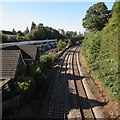
Taverner Trading Estate, Caerleon
Taverner Trading Estate occupies the yard behind the former Caerleon railway station where passenger services ended in 1962. The railway lines are part of the Welsh Marches Line.
Image: © Jaggery
Taken: 21 Jan 2020
0.06 miles
6
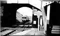
Caerleon Station
This train was heading north on the 'Eastern Valleys' route to Blaenavon. The station (and the route to Blaenavon) are both closed but this line is still open carrying the Cardiff-Manchester trains. [Looking NE]
Image: © John Thorn
Taken: Unknown
0.06 miles
7
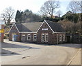
Former railway station building, Caerleon
Now known as Units 11 and 12, Taverner Trading Estate, Station Road, this is the
former Caerleon station building. The station closed in April 1962 following the cessation of local passenger services.
The building is now occupied by Caerleon Veterinary Centre, part of the Usk Veterinary Centre Group.
Image: © Jaggery
Taken: 14 Mar 2010
0.06 miles
8
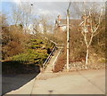
Steps from Taverner Trading Estate to Station Road, Caerleon
The steps turn through 90 degrees half way up. They connect Station Road (ahead) and Taverner Trading Estate, formerly the yard of Caerleon railway station, which closed in 1962.
Image: © Jaggery
Taken: 14 Mar 2010
0.06 miles
9
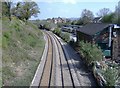
Former Caerleon railway station
The view along the site of the former Caerleon railway station, which closed in 1962. On the right is a part of Taverner Trading Estate. At the far end of the former station yard is the old station building http://www.geograph.org.uk/photo/1754155, now a veterinary centre.
Image: © Jaggery
Taken: 14 Mar 2010
0.06 miles
10
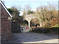
Station Road railway bridge, Caerleon
The bridge carries Station Road over the Newport to Cwmbran and The North railway lines.
Viewed from the edge of Taverner Trading Estate, formerly the station yard.
On the left is the edge of the former station building, http://www.geograph.org.uk/photo/1754155 now a veterinary centre.
Image: © Jaggery
Taken: 14 Mar 2010
0.06 miles