IMAGES TAKEN NEAR TO
Upper Garn Terrace, PONTYPOOL, NP4 9SG
Introduction
This page details the photographs taken nearby to Upper Garn Terrace, NP4 9SG by members of the Geograph project.
The Geograph project started in 2005 with the aim of publishing, organising and preserving representative images for every square kilometre of Great Britain, Ireland and the Isle of Man.

There are currently over 7.5m images from over14,400 individuals and you can help contribute to the project by visiting https://www.geograph.org.uk
Image Map
Images are licensed for reuse under creativecommons.org/licenses/by-sa/2.0
Notes
- Clicking on the map will re-center to the selected point.
- The higher the marker number, the further away the image location is from the centre of the postcode.
Image Listing (40 Images Found)
Images are licensed for reuse under creativecommons.org/licenses/by-sa/2.0
Image
Details
Distance
2
Terraced housing, Blaenavon
Typical workers' housing in the former South Wales coalfield.
Image: © Chris Allen
Taken: 2 May 2022
0.04 miles
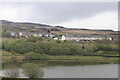
3
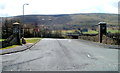
Lower Garn Terrace, Garn-yr-erw
A row of 20 houses viewed from the entrance road to Garn Lakes.
Image: © Jaggery
Taken: 3 Apr 2011
0.06 miles
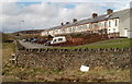
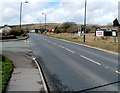
4
Upper Garn Terrace, Garn-yr-erw
The row of houses fronts on to Garn Road; the road in the centre serves Lower Garn Terrace (houses to the left just out of picture).
Image: © M J Roscoe
Taken: 29 Nov 2016
0.07 miles
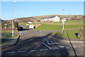
5
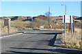
Road junction, Garn Road, Garn-yr-erw
Start of road to Garn Lakes from Garn Road, B4248, with colliery waste tips in the background in this former coal mining area.
Image: © M J Roscoe
Taken: 29 Nov 2016
0.10 miles
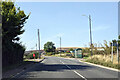
7
Moorland opposite Garn Lakes, Garn-yr-erw
Viewed from the access road http://www.geograph.org.uk/photo/2834065 into Garn Lakes, and Furnace Sidings station on the heritage Pontypool and Blaenavon Railway. The road here is at an elevation of about 390 metres (1,280 feet) above mean sea level.
Image: © Jaggery
Taken: 3 Apr 2011
0.11 miles
8
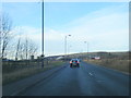
Entrance to Garn Lakes, Garn-yr-erw
Viewed across the B4248. The road leads into Garn Lakes, one of several Local Nature Reserves managed by Torfaen County Borough Council.
The road also leads to Furnace Sidings station on the heritage Pontypool and Blaenavon Railway.
Image: © Jaggery
Taken: 3 Apr 2011
0.12 miles
9
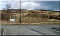
Turn left here for Garn Lakes and the steam railway, Garn-yr-erw
The left turn from Garn Road (B4248) leads into Garn Lakes, with access to Furnace Sidings station on the heritage Pontypool and Blaenavon Railway.
There is an old-style representation of a hand with a pointing finger on the OPEN TODAY sign on the right.
Image: © Jaggery
Taken: 3 Apr 2011
0.12 miles
10
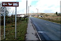
Turn left ahead for Garn Lakes and steam railway
The next left ahead on Garn Road (B4248) leads into Garn Lakes, with access to Furnace Sidings station on the heritage Pontypool and Blaenavon Railway.
Image: © Jaggery
Taken: 3 Apr 2011
0.12 miles