IMAGES TAKEN NEAR TO
Elgam Avenue, PONTYPOOL, NP4 9QY
Introduction
This page details the photographs taken nearby to Elgam Avenue, NP4 9QY by members of the Geograph project.
The Geograph project started in 2005 with the aim of publishing, organising and preserving representative images for every square kilometre of Great Britain, Ireland and the Isle of Man.

There are currently over 7.5m images from over14,400 individuals and you can help contribute to the project by visiting https://www.geograph.org.uk
Image Map
Images are licensed for reuse under creativecommons.org/licenses/by-sa/2.0
Notes
- Clicking on the map will re-center to the selected point.
- The higher the marker number, the further away the image location is from the centre of the postcode.
Image Listing (312 Images Found)
Images are licensed for reuse under creativecommons.org/licenses/by-sa/2.0
Image
Details
Distance
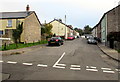
1
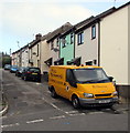
Yellow van on a Blaenavon corner
The Nolan Roadmarking van is parked in Alma Street, at the corner of Ellick Street.
Image: © Jaggery
Taken: 2 Oct 2015
0.06 miles
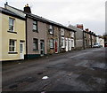
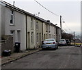
2
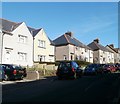
Change of house type, Ellick Street, Blaenavon
Northeastwards of Alma Street, http://www.geograph.org.uk/photo/2134211 the housing type changes from terraced http://www.geograph.org.uk/photo/2134201 to semi-detached.
Image: © Jaggery
Taken: 25 Oct 2010
0.06 miles
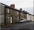
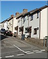
3
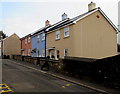
Pastel colours in Blaenavon
Three recently-built houses viewed across Ellick Street in early October 2015.
A May 2011 Google Earth Street View shows no houses here, only a vacant area partly grass covered.
Image: © Jaggery
Taken: 2 Oct 2015
0.06 miles
4
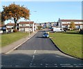
Looking towards Llanfoist Crescent, Blaenavon
The view from the corner of Upper Woodland Street along a short unnamed connecting road to Llanfoist Crescent. The houses at right angles to the roadway are on Gilchrist Walk on the right and Morgan Rise on the left.
Image: © Jaggery
Taken: 25 Oct 2010
0.07 miles
5
Phillips Street, Blaenavon
Ascending northwards from King Street. The camera is alongside The Fountain (Fountain Inn). http://www.geograph.org.uk/photo/4682812
Image: © Jaggery
Taken: 2 Oct 2015
0.07 miles
6
West side of Phillips Street, Blaenavon
The gap in the houses is at the Castle Street junction. http://www.geograph.org.uk/photo/4682832
Image: © Jaggery
Taken: 22 Nov 2016
0.08 miles
7
Phillips Street houses north of Castle Street, Blaenavon
The Castle Street http://www.geograph.org.uk/photo/4682832 junction is on the left.
Image: © Jaggery
Taken: 22 Nov 2016
0.08 miles
8
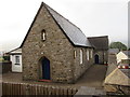
Catholic Church in Blaenavon
Sacred Heart and St Felix Catholic Church viewed from Ellick Street. http://www.geograph.org.uk/photo/4682762 to another view.
The church is part of the Roman Catholic Archdiocese of Cardiff.
Image: © Jaggery
Taken: 2 Oct 2015
0.08 miles
9
Maxworthy Road houses, Blaenavon
Viewed from the corner of Rifle Street looking along Maxworthy Road towards Phillips Street.
Image: © Jaggery
Taken: 2 Oct 2015
0.08 miles
10
Alma Street, Blaenavon
Houses on the NE side of the street, viewed from the corner of Ellick Street.
Image: © Jaggery
Taken: 25 Oct 2010
0.08 miles