IMAGES TAKEN NEAR TO
High Street, PONTYPOOL, NP4 9QD
Introduction
This page details the photographs taken nearby to High Street, NP4 9QD by members of the Geograph project.
The Geograph project started in 2005 with the aim of publishing, organising and preserving representative images for every square kilometre of Great Britain, Ireland and the Isle of Man.

There are currently over 7.5m images from over14,400 individuals and you can help contribute to the project by visiting https://www.geograph.org.uk
Image Map
Images are licensed for reuse under creativecommons.org/licenses/by-sa/2.0
Notes
- Clicking on the map will re-center to the selected point.
- The higher the marker number, the further away the image location is from the centre of the postcode.
Image Listing (728 Images Found)
Images are licensed for reuse under creativecommons.org/licenses/by-sa/2.0
Image
Details
Distance
1
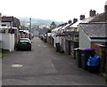
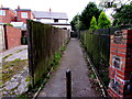
Lane from Lower Waun Street to High Street, Blaenavon
Extending for 130 metres between the backs of houses.
Image: © Jaggery
Taken: 2 Oct 2015
0.01 miles
2
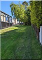
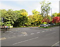
Green and trees, High Street, Blaenavon
The bus shelter is alongside the terminus of Stagecoach bus route X24 from Newport.
Image: © Jaggery
Taken: 20 May 2023
0.01 miles
3
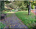
Blaenavon benches
At the western edge of Broad Street Car Park, Blaenavon. http://www.geograph.org.uk/photo/4671322
Image: © Jaggery
Taken: 23 Sep 2015
0.02 miles
4
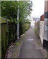
Bethel Lane, Blaenavon
From King Street to Upper Waun Street (ahead).
Image: © Jaggery
Taken: 2 Oct 2015
0.02 miles
5
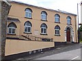
Bethel Baptist chapel
One of many churches built in Blaenavon for workers and their families in the local iron industry.
Image: © David Smith
Taken: 7 Jul 2011
0.02 miles
6
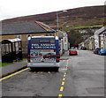
Phil Anslow & Sons bus in High Street, Blaenavon
The Optare bus awaits departure on Route 31 to Brynmawr.
Image: © Jaggery
Taken: 22 Nov 2016
0.02 miles
7
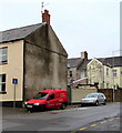
Red van on a Blaenavon corner
The South Wales Roofing & Property Maintenance van is on the corner of High Street and Lower Waun Street.
Image: © Jaggery
Taken: 22 Nov 2016
0.02 miles
8
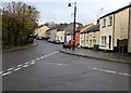
From Queen Street to King Street, Blaenavon
At the northern end of Broad Street, Queen Street from the right joins the southern end of King Street.
Image: © Jaggery
Taken: 22 Nov 2016
0.03 miles
9
Short cut to King Street, Blaenavon
Bethel Lane viewed from the corner of High Street and Upper Waun Street.
Image: © Jaggery
Taken: 2 Oct 2015
0.03 miles
10
Entrance to Broad Street Car Park, Blaenavon
The free car park is at the northern end of Broad Street, Blaenavon's main shopping and commercial street.
The information board in the car park states that Broad Street was originally named Heol y Nant. In the 19th century, its shops and businesses supplied all the needs of an ever-growing number of ironworkers, coalminers and their families. As the coal and steel industries declined in the 20th century, people moved away from Blaenavon to find work, so many traditional businesses closed.
Image: © Jaggery
Taken: 23 Sep 2015
0.03 miles