IMAGES TAKEN NEAR TO
Vincent Street, PONTYPOOL, NP4 9QB
Introduction
This page details the photographs taken nearby to Vincent Street, NP4 9QB by members of the Geograph project.
The Geograph project started in 2005 with the aim of publishing, organising and preserving representative images for every square kilometre of Great Britain, Ireland and the Isle of Man.

There are currently over 7.5m images from over14,400 individuals and you can help contribute to the project by visiting https://www.geograph.org.uk
Image Map
Images are licensed for reuse under creativecommons.org/licenses/by-sa/2.0
Notes
- Clicking on the map will re-center to the selected point.
- The higher the marker number, the further away the image location is from the centre of the postcode.
Image Listing (734 Images Found)
Images are licensed for reuse under creativecommons.org/licenses/by-sa/2.0
Image
Details
Distance
1
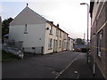
Vincent Street, Blaenavon
Cul-de-sac extending for 45 metres from the east side of High Street.
Image: © Jaggery
Taken: 2 Oct 2015
0.01 miles
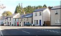
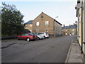
2
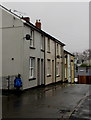
Vincent Street houses, Blaenavon
In a cul-de-sac on the east side of High Street.
Image: © Jaggery
Taken: 12 Dec 2019
0.01 miles
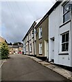
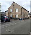
3
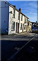
Sunny side of Vincent Street, Blaenavon
Viewed from the corner of High Street on a cold, sunny day in January 2023.
Image: © Jaggery
Taken: 17 Jan 2023
0.01 miles
4
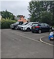
Small car park, Vincent Street, Blaenavon
For the residents of nearby Lion Court. https://www.geograph.org.uk/photo/7233977
Image: © Jaggery
Taken: 20 Jul 2022
0.01 miles
5
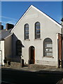
Blaenavon Concert Band Bandroom
Located on Broad Street, between numbers 45 and 46. Shown on maps as a hall, it was probably once a church or chapel, but the name at the top of the frontage has been obliterated. A hand-written sign attached to the glass above the doorway shows Blaenafon Concert Band Bandroom.
Image: © Jaggery
Taken: 25 Oct 2010
0.01 miles
6
King Street, Blaenavon
Houses on King Street, viewed from the northern end of Broad Street. The broken double white lines on the right are at the edge of Old Queen Street. The roadway is 350 metres (about 1150 feet) above sea level.
Image: © Jaggery
Taken: 25 Oct 2010
0.01 miles
7
West along Vincent Street, Blaenavon
Towards High Street from the dead end of Vincent Street.
Image: © Jaggery
Taken: 20 Jul 2022
0.01 miles
8
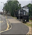
High Street bus terminus, Blaenavon
In July 2022 this bus stop is the terminus of Stagecoach service X24 from Newport via Cwmbran and Pontypool, and the starting point for the return journey.
Image: © Jaggery
Taken: 20 Jul 2022
0.01 miles
9
Vincent Street parking area, Blaenavon
Vincent Street is a short cul-de-sac on the east side of High Street.
Image: © Jaggery
Taken: 2 Oct 2015
0.02 miles
10
North side of Lion Court, Blaenavon
Flats viewed across Vincent Street.
Image: © Jaggery
Taken: 20 Jul 2022
0.02 miles