IMAGES TAKEN NEAR TO
High Street, PONTYPOOL, NP4 9PU
Introduction
This page details the photographs taken nearby to High Street, NP4 9PU by members of the Geograph project.
The Geograph project started in 2005 with the aim of publishing, organising and preserving representative images for every square kilometre of Great Britain, Ireland and the Isle of Man.

There are currently over 7.5m images from over14,400 individuals and you can help contribute to the project by visiting https://www.geograph.org.uk
Image Map
Images are licensed for reuse under creativecommons.org/licenses/by-sa/2.0
Notes
- Clicking on the map will re-center to the selected point.
- The higher the marker number, the further away the image location is from the centre of the postcode.
Image Listing (755 Images Found)
Images are licensed for reuse under creativecommons.org/licenses/by-sa/2.0
Image
Details
Distance
1
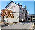
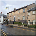
Blaenavon Library
Torfaen County Borough library located on Lion Street. Formerly derelict council offices and town hall, the building has been converted and renovated, one of many transformations in Blaenavon since World Heritage status was achieved in 2000.
Image: © Jaggery
Taken: 25 Oct 2010
0.01 miles
2
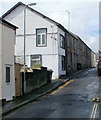
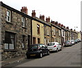
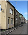
Burford Street, Blaenavon
Houses on the south side of the street, viewed from the Broad Street end.
Image: © Jaggery
Taken: 3 Apr 2011
0.01 miles
3
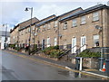
Lion Street houses, Blaenavon
Houses on the north side of the street, opposite the library. http://www.geograph.org.uk/photo/2136514
Image: © Jaggery
Taken: 3 Apr 2011
0.01 miles
4
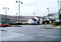
Lion Street car park, Blaenavon
Small, free car park on the south side of Lion Street.
Image: © Jaggery
Taken: 3 Apr 2011
0.01 miles
5
Blaenavon Customer Centre
Torfaen County Borough premises at 7-12 Lion Court, on the corner of Lion Street and High Street, viewed across Lion Street.
Image: © Jaggery
Taken: 3 Apr 2011
0.01 miles
6
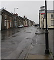
West side of High Street, Blaenavon
In 2015, this High Street is mostly residential. The town's main shopping and commercial street is Broad Street.
Image: © Jaggery
Taken: 25 Sep 2015
0.01 miles
7
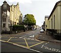
Southern end of High Street, Blaenavon
High Street ascends from the B4246 Church Road. The War Memorial Tower http://www.geograph.org.uk/photo/4673387 is on the left.
Image: © Jaggery
Taken: 25 Sep 2015
0.01 miles
8
High Street bus stop near Burford Street, Blaenavon
In December 2019 the bus stop sign shows that this is a stop on
Stagecoach Route 24, Stagecoach Gold Route X24 and Phil Anslow Route 31.
Image: © Jaggery
Taken: 12 Dec 2019
0.01 miles
9
Burford Street houses, Blaenavon
Burford Street extends for 85 metres from Broad Street to High Street (ahead).
Image: © Jaggery
Taken: 15 Aug 2017
0.02 miles
10
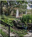
Headstones near Bethlehem Court, Blaenavon
In the small burial ground adjoining Bethlehem Congregational Chapel.
Image: © Jaggery
Taken: 14 Sep 2024
0.02 miles