IMAGES TAKEN NEAR TO
Capel Newydd Avenue, PONTYPOOL, NP4 9LR
Introduction
This page details the photographs taken nearby to Capel Newydd Avenue, NP4 9LR by members of the Geograph project.
The Geograph project started in 2005 with the aim of publishing, organising and preserving representative images for every square kilometre of Great Britain, Ireland and the Isle of Man.

There are currently over 7.5m images from over14,400 individuals and you can help contribute to the project by visiting https://www.geograph.org.uk
Image Map
Images are licensed for reuse under creativecommons.org/licenses/by-sa/2.0
Notes
- Clicking on the map will re-center to the selected point.
- The higher the marker number, the further away the image location is from the centre of the postcode.
Image Listing (90 Images Found)
Images are licensed for reuse under creativecommons.org/licenses/by-sa/2.0
Image
Details
Distance
1
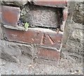
Ordnance Survey Cut Mark
This damaged OS cut mark can be found on the wall of Glenside, NE side of Blaenavon Road. It marks a point 312.877m above mean sea level.
Image: © Adrian Dust
Taken: 18 Aug 2018
0.06 miles
2
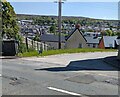
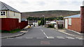
Hillside view, Blaenavon
Viewed across the B4246 Varteg Road and Rowan Way in May 2023.
Image: © Jaggery
Taken: 20 May 2023
0.07 miles
3
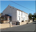
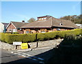
Llanover Road houses, Blaenavon
Houses on the north side of Llanover Road, a few metres west of the junction with Brights Lane.
Image: © Jaggery
Taken: 25 Oct 2010
0.09 miles
4
Bus stop dwarfed by trees, Cwmavon Road, Blaenavon
The bus stop is on the corner of Capel Newydd Avenue.
Image: © Jaggery
Taken: 28 Apr 2011
0.10 miles
5
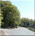
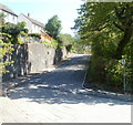
Down Coed Road, Blaenavon
Coed Road descends from Llanover Road towards the A4043 Cwmavon Road nearly 300 metres ahead.
Image: © Jaggery
Taken: 23 Sep 2015
0.10 miles
6
Corner of Llanover Road and Brights Lane, Blaenavon
Viewed across Llanover Road.
Image: © Jaggery
Taken: 25 Oct 2010
0.11 miles
7
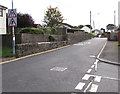
Capel Newydd Avenue, Blaenavon
Capel Newydd Avenue climbs away from Cwmavon Road.
Image: © Jaggery
Taken: 28 Apr 2011
0.11 miles
8
Warning traffic signs, Llanover Road, Blaenavon
From the Coed Road junction. http://www.geograph.org.uk/photo/4672444 The triangular signs warn of a narrower roadway without pavements ahead.
Image: © Jaggery
Taken: 23 Sep 2015
0.12 miles
9
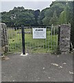
Garden of Rest notice facing Llanover Road, Blaenavon
The Torfaen Borough notice shows
THIS FORMER CHURCHYARD IS NOW DESIGNATED AS A GARDEN OF REST.
PLEASE REFRAIN FROM PLAYING BALL GAMES.
Image: © Jaggery
Taken: 23 Jun 2024
0.12 miles
10
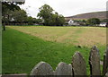
Middle Coedcae Garden of Rest, Blaenavon
Viewed from the edge of Blaenavon Park looking towards Llanover Road. A former churchyard has been designated a Garden of Rest. Gravestones are arranged vertically along the perimeter.
Image: © Jaggery
Taken: 23 Sep 2015
0.12 miles