IMAGES TAKEN NEAR TO
Bryn Welon Close, PONTYPOOL, NP4 9JL
Introduction
This page details the photographs taken nearby to Bryn Welon Close, NP4 9JL by members of the Geograph project.
The Geograph project started in 2005 with the aim of publishing, organising and preserving representative images for every square kilometre of Great Britain, Ireland and the Isle of Man.

There are currently over 7.5m images from over14,400 individuals and you can help contribute to the project by visiting https://www.geograph.org.uk
Image Map
Images are licensed for reuse under creativecommons.org/licenses/by-sa/2.0
Notes
- Clicking on the map will re-center to the selected point.
- The higher the marker number, the further away the image location is from the centre of the postcode.
Image Listing (88 Images Found)
Images are licensed for reuse under creativecommons.org/licenses/by-sa/2.0
Image
Details
Distance
1
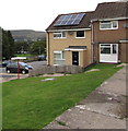
Bryn Welon Close, Blaenavon
Houses on the south side of Upper Coedcae Road, north of Blaenavon Park.
Image: © Jaggery
Taken: 23 Sep 2015
0.00 miles
2
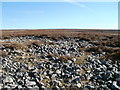
Looking west from high ground, Upper Coedcae
The view west from ground at about 430 metres (1410 feet) above sea level.
The view
north http://www.geograph.org.uk/photo/2134745
south http://www.geograph.org.uk/photo/2134761
east http://www.geograph.org.uk/photo/2134768
from the same spot.
Image: © Jaggery
Taken: 25 Oct 2010
0.02 miles
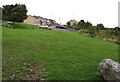
3
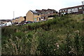
Upper Coedcae weeds and houses, Blaenavon
Bryn Welon Close and Upper Coedcae Road houses viewed from a path at the edge of Blaenavon Park.
Image: © Jaggery
Taken: 23 Sep 2015
0.03 miles
4
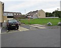
Yellow corner of the Bryn Welon Close parking area, Blaenavon
This part of the car park is reserved for Blue Badge holders.
The blue badge lets disabled drivers park nearer to where they're going.
For example the yellow marked area in a railway station car park is near the station entrance.
Image: © Jaggery
Taken: 23 Sep 2015
0.03 miles
5
Bryn Welon Close signpost, Upper Coedcae, Blaenavon
One arm points right towards 34-57 Bryn Welon Close. The other arm points towards Giles Road houses.
Image: © Jaggery
Taken: 23 Sep 2015
0.04 miles
6
Boulders at the edge of Bryn Welon Close car park, Upper Coedcae, Blaenavon
More effective in keeping vehicles off the grass than a Keep Off The Grass sign.
Image: © Jaggery
Taken: 23 Sep 2015
0.04 miles
7
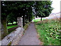
Path alongside Blaenavon Park perimeter wall, Blaenavon
Descending from this http://www.geograph.org.uk/photo/4672145 metal barrier.
Image: © Jaggery
Taken: 23 Sep 2015
0.04 miles
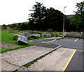
8
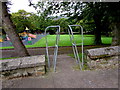
Inwardly-sloping barrier at the northern entrance to Blaenavon Park, Blaenavon
Preventing vehicles entering the park. A children's playground http://www.geograph.org.uk/photo/4672095 is in the background.
Image: © Jaggery
Taken: 23 Sep 2015
0.05 miles
9
Grassy bank between car parks, Upper Coedcae, Blaenavon
Between Bryn Welon Close car park (on this side) and Giles Road car park.
Image: © Jaggery
Taken: 23 Sep 2015
0.05 miles
10
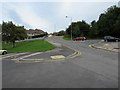
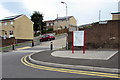
Double yellow lines, Giles Road, Upper Coedcae, Blaenavon
Looking north along Giles Road towards Upper Coedcae Road. Double yellow lines on both sides of the road make parking illegal here at any time, except in the parking areas on the left and right.
Image: © Jaggery
Taken: 23 Sep 2015
0.06 miles