IMAGES TAKEN NEAR TO
Llanover Road, PONTYPOOL, NP4 9HT
Introduction
This page details the photographs taken nearby to Llanover Road, NP4 9HT by members of the Geograph project.
The Geograph project started in 2005 with the aim of publishing, organising and preserving representative images for every square kilometre of Great Britain, Ireland and the Isle of Man.

There are currently over 7.5m images from over14,400 individuals and you can help contribute to the project by visiting https://www.geograph.org.uk
Image Map
Images are licensed for reuse under creativecommons.org/licenses/by-sa/2.0
Notes
- Clicking on the map will re-center to the selected point.
- The higher the marker number, the further away the image location is from the centre of the postcode.
Image Listing (70 Images Found)
Images are licensed for reuse under creativecommons.org/licenses/by-sa/2.0
Image
Details
Distance
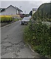
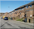
1
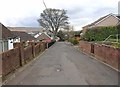
Llanover Road, Blaenavon
Looking WNW down Llanover Road. Note the extensive patchwork of road works and repairs.
Image: © David P Howard
Taken: 13 Apr 2012
0.03 miles
2
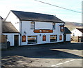
The Pottery, Blaenavon
Pub on Llanover Road, viewed from Giles Road. Attractions advertised on boards on the wall include bar food; real ales; beer garden; pool&darts; big screen TV.
Image: © Jaggery
Taken: 25 Oct 2010
0.04 miles
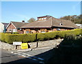
3
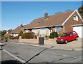
Llanover Road Estate, Blaenavon
Bungalows on Llanover Road Estate, a small area of housing along two parallel roads on the west side of Giles Road.
Image: © Jaggery
Taken: 25 Oct 2010
0.04 miles
4
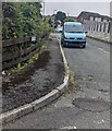
Blue van parked in The Firs, Blaenavon
Looking to the NE from Llanover Road.
Image: © Jaggery
Taken: 23 Jun 2024
0.05 miles
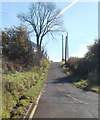
5
Up Brights Lane, Blaenavon
Brights Lane ascends to the NE away from Llanover Road.
Image: © Jaggery
Taken: 23 Jun 2024
0.08 miles
6
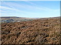
Looking south from high ground, Upper Coedcae
The view south from ground at about 430 metres (1410 feet) above sea level.
The view
north http://www.geograph.org.uk/photo/2134745
west http://www.geograph.org.uk/photo/2134755
east http://www.geograph.org.uk/photo/2134768
from the same spot.
Image: © Jaggery
Taken: 25 Oct 2010
0.09 miles
7
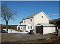
Two houses at the SE edge of Upper Coedcae Road, Blaenavon
Two semi-detached houses viewed from the edge of moorland at the eastern boundary of residential Blaenavon.
Image: © Jaggery
Taken: 25 Oct 2010
0.10 miles
8
Blaenavon : Upper Coedcae Road narrows to single track
Beyond the turning for Giles Road (lower right corner), the eastern end of Upper Coedcae Road is single track, at the eastern edge of residential Blaenavon.
Image: © Jaggery
Taken: 25 Oct 2010
0.10 miles
9
Giles Road, Blaenavon
Houses on the NE side of Giles Road, in the highest (NE) section of Blaenavon.
The street level here is about 390 metres (1280 feet) above sea level.
Image: © Jaggery
Taken: 25 Oct 2010
0.10 miles
10
Corner of Llanover Road and Brights Lane, Blaenavon
Viewed across Llanover Road.
Image: © Jaggery
Taken: 25 Oct 2010
0.10 miles