IMAGES TAKEN NEAR TO
Llanover Road, PONTYPOOL, NP4 9HR
Introduction
This page details the photographs taken nearby to Llanover Road, NP4 9HR by members of the Geograph project.
The Geograph project started in 2005 with the aim of publishing, organising and preserving representative images for every square kilometre of Great Britain, Ireland and the Isle of Man.

There are currently over 7.5m images from over14,400 individuals and you can help contribute to the project by visiting https://www.geograph.org.uk
Image Map
Images are licensed for reuse under creativecommons.org/licenses/by-sa/2.0
Notes
- Clicking on the map will re-center to the selected point.
- The higher the marker number, the further away the image location is from the centre of the postcode.
Image Listing (434 Images Found)
Images are licensed for reuse under creativecommons.org/licenses/by-sa/2.0
Image
Details
Distance
1
First House, Llanover Road, Blaenavon
First House is at the western end of Llanover Road, near the Ton-Mawr Street junction.
Image: © Jaggery
Taken: 23 Sep 2015
0.01 miles
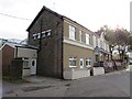
2
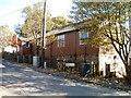
St Paul's Hall, Blaenavon
Church hall opposite St Paul's Church. http://www.geograph.org.uk/photo/4671607 A yellow notice in a window shows that the hall is the location of the Alison Lee Academy of Dance, a dance school teaching ballet, tap and modern dance.
Image: © Jaggery
Taken: 23 Sep 2015
0.01 miles
3
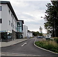
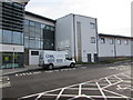
Side road ascending from Middle Coedcae, Blaenavon
Blaenavon Pharmacy http://www.geograph.org.uk/photo/5597431 is on the left. The rear of the National Health Service Blaenavon Resource Centre is ahead.
Image: © Jaggery
Taken: 23 Sep 2015
0.02 miles
4
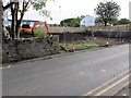
Doosan excavator in a fenced-off area of Llanover Road, Blaenavon
Viewed in late September 2015. This was formerly an area of trees and bushes in a 35 metre gap between houses.
Image: © Jaggery
Taken: 23 Sep 2015
0.02 miles
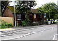
5
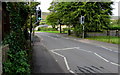
Pelican crossing, Middle Coedcae, Blaenavon
St Paul's Hall http://www.geograph.org.uk/photo/4671629 is on the left. Chambers Dictionary states that the term pelican crossing is adapted from "pedestrian light controlled crossing".
Image: © Jaggery
Taken: 23 Sep 2015
0.02 miles
6
Cook Group white van in Blaenavon
Parked in the drop off/pick up area at the rear of the National Health Service Blaenavon Resource Centre. Text on the van shows that Cook Group's business includes building preservation, condensation control, structural waterproofing.
Image: © Jaggery
Taken: 23 Sep 2015
0.02 miles
7
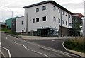
Blaenavon Pharmacy, Blaenavon
Viewed across the road named Middle Coedcae.
Image: © Jaggery
Taken: 23 Sep 2015
0.03 miles
8
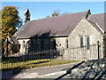
St Paul's Church, Blaenavon
Church in Wales church on the corner of Llanover Road and Middle Coedcae Road.
Built in only 6 months, it was opened and consecrated by the Bishop of Llandaff in October 1893.
Image: © Jaggery
Taken: 25 Oct 2010
0.03 miles
9
St Paul's Hall, Blaenavon
Church hall in Middle Coedcae, opposite St Paul's Church. http://www.geograph.org.uk/photo/2135913
Image: © Jaggery
Taken: 25 Oct 2010
0.03 miles
10
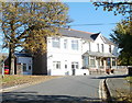
Three houses at the western end of Llanover Road, Blaenavon
A row of 3 houses viewed from the corner of Ton Mawr Road. The house nearest the camera is named First House.
Image: © Jaggery
Taken: 25 Oct 2010
0.03 miles