IMAGES TAKEN NEAR TO
Rowan Way, Woodland View, PONTYPOOL, NP4 9EE
Introduction
This page details the photographs taken nearby to Rowan Way, Woodland View, NP4 9EE by members of the Geograph project.
The Geograph project started in 2005 with the aim of publishing, organising and preserving representative images for every square kilometre of Great Britain, Ireland and the Isle of Man.

There are currently over 7.5m images from over14,400 individuals and you can help contribute to the project by visiting https://www.geograph.org.uk
Image Map
Images are licensed for reuse under creativecommons.org/licenses/by-sa/2.0
Notes
- Clicking on the map will re-center to the selected point.
- The higher the marker number, the further away the image location is from the centre of the postcode.
Image Listing (231 Images Found)
Images are licensed for reuse under creativecommons.org/licenses/by-sa/2.0
Image
Details
Distance
1
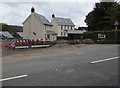
Recently-built houses, Varteg Road, Blaenavon
On the east side of the B4246 Varteg Road viewed in September 2015.
Image: © Jaggery
Taken: 20 Sep 2015
0.03 miles
2
Road not yet fully open, Woodland View, Blaenavon
In September 2015, a temporary metal barrier is across the road behind
the cars during construction of the Woodland View housing development.
Image: © Jaggery
Taken: 20 Sep 2015
0.03 miles
3
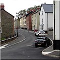
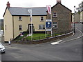
Corner of Sycamore Road and Varteg Road, Blaenavon
Recently-built house on Sycamore Road, viewed across Varteg Road.
Image: © Jaggery
Taken: 25 Oct 2010
0.04 miles
4
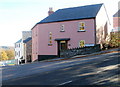
Junction of Varteg Road and Rowan Way, Blaenavon
Viewed across the B4246 Varteg Road.
Image: © Jaggery
Taken: 20 May 2023
0.04 miles
5
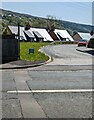
Woodland View marketing suite, Blaenavon
Viewed in September 2015 when construction of the Woodland View housing development is not yet complete.
Image: © Jaggery
Taken: 20 Sep 2015
0.05 miles
6
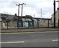
Woodland View banner, Varteg Road, Blaenavon
In September 2015 the banner shows that Woodland View houses in the background
are a development by ButlerWall Homes and Parry's Property.
Image: © Jaggery
Taken: 20 Sep 2015
0.05 miles
7
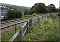
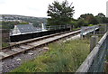
Single-track railway, Blaenavon
Viewed from National Cycle Network route 492. The single track is southeast of Blaenavon (High Level) railway station, the current southern terminus of the heritage Pontypool & Blaenavon Railway. In September 2015, this track ends at buffers (inaccessible to the public) at the edge of the combined cycleway and footpath, about 350 metres from the camera.
Image: © Jaggery
Taken: 20 Sep 2015
0.05 miles
8
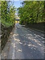
Varteg Road, Blaenavon
Looking north down the B4246 Varteg Road. Ahead for the heritage
Pontypool & Blaenavon Railway and Blaenavon High Level Station.
Image: © Jaggery
Taken: 20 May 2023
0.05 miles
9
Railway bridge over Varteg Road, Blaenavon
This part of the heritage Pontypool & Blaenavon Railway is beyond the SE end of Blaenavon (High Level) railway station, the railway's current (2015) southern terminus. The line is used by a locomotive during the process to reposition it from the front of a train to what was the back of the train, for the return journey.
This line is in the background here. http://www.geograph.org.uk/photo/4677069
Image: © Jaggery
Taken: 20 Sep 2015
0.05 miles
10
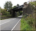
North side of Varteg Road railway bridge, Blaenavon
The bridge carries the heritage Pontypool & Blaenavon Railway over the B4246 Varteg Road near Blaenavon (High Level) station. The sign on the left shows headroom 13' 9".
Image: © Jaggery
Taken: 20 Sep 2015
0.05 miles