IMAGES TAKEN NEAR TO
Varteg Road, PONTYPOOL, NP4 9DR
Introduction
This page details the photographs taken nearby to Varteg Road, NP4 9DR by members of the Geograph project.
The Geograph project started in 2005 with the aim of publishing, organising and preserving representative images for every square kilometre of Great Britain, Ireland and the Isle of Man.

There are currently over 7.5m images from over14,400 individuals and you can help contribute to the project by visiting https://www.geograph.org.uk
Image Map
Images are licensed for reuse under creativecommons.org/licenses/by-sa/2.0
Notes
- Clicking on the map will re-center to the selected point.
- The higher the marker number, the further away the image location is from the centre of the postcode.
Image Listing (380 Images Found)
Images are licensed for reuse under creativecommons.org/licenses/by-sa/2.0
Image
Details
Distance
1
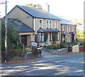
Oakfield B&B, Blaenavon
Nearest the camera is Oakfield B&B (bed and breakfast accommodation), which occupies two early 20th century houses that have been combined into one property. It is part of Oakfield Terrace, built by a local farmer as four properties alongside Varteg Road to house members of his family.
Image: © Jaggery
Taken: 25 Oct 2010
0.02 miles
2
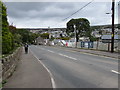
Down Varteg Road, Blaenavon
The B4246 Varteg Road descends towards the centre of Blaenavon. In September 2015, a banner on the right states that new homes in the Woodland View development will be available soon.
Image: © Jaggery
Taken: 20 Sep 2015
0.03 miles
3
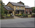
Oakfield Terrace, Varteg Road, Blaenavon
Viewed from the corner of Sycamore Road. Oakfield B&B (bed and breakfast accommodation) is on the left.
Image: © Jaggery
Taken: 20 Sep 2015
0.04 miles
4
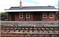
Blaenavon (High Level) railway station building
Viewed in late September 2015. This building was little more than a shell 4 years earlier. http://www.geograph.org.uk/photo/2509824
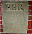
A stone inscription http://www.geograph.org.uk/photo/4677086 on the wall between a window and door shows
P & BR EXTENSION SOUTH TO B.H.L OPENED BY PETE WATERMAN O.B.E 17TH SEPT 2010.
(P & BR = Pontypool & Blaenavon Railway. B.H.L = Blaenavon (High Level)).
Image: © Jaggery
Taken: 20 Sep 2015
0.04 miles
5
Blaenavon (High Level) railway station plaque
Located here. http://www.geograph.org.uk/photo/4677085
Image: © Jaggery
Taken: 20 Sep 2015
0.04 miles
6
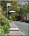
Sycamore Road bus stop and shelter, Blaenavon
Alongside the B4246 Varteg Road opposite Sycamore Road.
Image: © Jaggery
Taken: 20 May 2023
0.04 miles
7
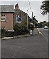
Corner of Varteg Road and Sycamore Road, Blaenavon
The bilingual name sign facing the B4246 Varteg Road
shows that Sycamore Road is Heol y Sycamorwydd in Welsh.
Image: © Jaggery
Taken: 20 Sep 2015
0.04 miles
8
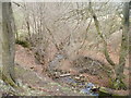
Small tributary of the Afon Lwyd, Blaenavon
An unnamed stream, having passed under Varteg Road, flows through a narrow wooded area towards the Afon Lwyd, about 100 metres away.
Image: © Jaggery
Taken: 3 Apr 2011
0.04 miles
9
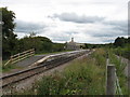
Blaenavon High Level Station, P&BR
The Pontypool & Blaenavon Railway's new extension terminates here; the station building is under construction.
Image: © Gareth James
Taken: 18 Sep 2010
0.05 miles
10
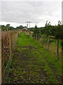
Path by the Railway
A grassy path alongside the Pontypooland Blaenavon Railway, reached from Blaenavon High Level station.
Image: © David Roberts
Taken: 18 Sep 2010
0.05 miles