IMAGES TAKEN NEAR TO
Gething Terrace, PONTYPOOL, NP4 9DN
Introduction
This page details the photographs taken nearby to Gething Terrace, NP4 9DN by members of the Geograph project.
The Geograph project started in 2005 with the aim of publishing, organising and preserving representative images for every square kilometre of Great Britain, Ireland and the Isle of Man.

There are currently over 7.5m images from over14,400 individuals and you can help contribute to the project by visiting https://www.geograph.org.uk
Image Map
Images are licensed for reuse under creativecommons.org/licenses/by-sa/2.0
Notes
- Clicking on the map will re-center to the selected point.
- The higher the marker number, the further away the image location is from the centre of the postcode.
Image Listing (90 Images Found)
Images are licensed for reuse under creativecommons.org/licenses/by-sa/2.0
Image
Details
Distance
1
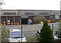
Part of the industrial area, Forgeside, Blaenavon
A fenced-off area of industrial buildings extends for about 600 metres on the north side of the residential area of Forgeside. This small section, viewed from Forge Road, includes the entrance to the "large rings machine shop".
Image: © Jaggery
Taken: 15 Apr 2011
0.03 miles
2
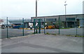
Industrial area, Forgeside, Blaenavon
A view through the fence, from a bend in Forge Road.
Industrial buildings extend for about 600 metres on the north side of the residential area of Forgeside.
Image: © Jaggery
Taken: 15 Apr 2011
0.03 miles
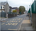
3
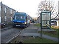
Forgeside Bus Stop
A bus stop by terraced houses in Forgeside, on the last day the bus service was operated by Stagecoach.
Image: © David Roberts
Taken: 21 Feb 2009
0.05 miles
4
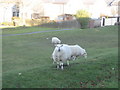
Forgeside Village Sheep
Sheep nibbling grass and posing for the camera in Forgeside village.
Image: © David Roberts
Taken: 21 Feb 2009
0.06 miles
5
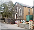
Zion Baptist Church, Forgeside, Blaenavon
Located on the south side of Forge Road, Forgeside. A stone inscription at the top of the building shows 1874 English Baptist Church. It opened in 1875 as a daughter church to Broad Street Baptist Church http://www.geograph.org.uk/photo/1854243 in the centre of Blaenavon.
Image: © Jaggery
Taken: 15 Apr 2011
0.07 miles
6
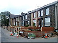
Forge Road houses, Forgeside, Blaenavon
Looking along Forge Road towards Zion Baptist Church http://www.geograph.org.uk/photo/2371440
Image: © Jaggery
Taken: 15 Apr 2011
0.07 miles
7
Abandoned school, Forgeside, Blaenavon
The derelict school is on the corner of Forge Road and Oxford Terrace.
Image: © Jaggery
Taken: 15 Apr 2011
0.07 miles
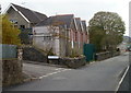
8
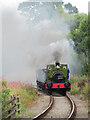
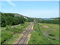
Pontypool & Blaenavon Railway
Andrew Barclay 0-4-0ST Rosyth No. 1 climbs away from Blaenavon High Level station with a train of mineral wagons during the Blaenavon Heritage Railway's steam gala.
Image: © Gareth James
Taken: 11 Sep 2021
0.07 miles
10
Forge Road bus stop, Forgeside, Blaenavon
A view west along Forge Road. The large building next to a tree is the derelict former school http://www.geograph.org.uk/photo/2850050 on the corner of Oxford Terrace. The wall and green fence on the right are at the perimeter of an industrial area extending for about 600 metres along the north side of the residential part of Forgeside.
Image: © Jaggery
Taken: 15 Apr 2011
0.07 miles