1
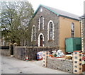
Zion Baptist Church, Forgeside, Blaenavon
Located on the south side of Forge Road, Forgeside. A stone inscription at the top of the building shows 1874 English Baptist Church. It opened in 1875 as a daughter church to Broad Street Baptist Church http://www.geograph.org.uk/photo/1854243 in the centre of Blaenavon.
Image: © Jaggery
Taken: 15 Apr 2011
0.02 miles
2
Abandoned school, Forgeside, Blaenavon
The derelict school is on the corner of Forge Road and Oxford Terrace.
Image: © Jaggery
Taken: 15 Apr 2011
0.02 miles
3
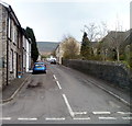
Forge Road houses, Forgeside, Blaenavon
Looking along Forge Road towards Zion Baptist Church http://www.geograph.org.uk/photo/2371440
Image: © Jaggery
Taken: 15 Apr 2011
0.02 miles
4
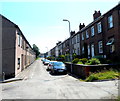
D row and E row houses, Forgeside
The rows of houses are named, not the street. D Row is on the left, E Row is on the right.
Image: © Jaggery
Taken: 22 Jul 2012
0.03 miles
5
Field footpath to rear of Coity Terrace
The path
Image goes down to a wooden stile - horizontal brown bars.
Image: © M J Roscoe
Taken: 6 Jan 2023
0.04 miles
6
Footpath up from rear of Coity Terrace
The footpath goes through the horse pasture to a bridleway on the flank of Coety Mountain.
Image: © M J Roscoe
Taken: 6 Jan 2023
0.04 miles
7
Clapham Terrace, Forgeside
Clapham Terrace is a 150 metre long cul-de-sac, viewed here from the corner of Forge Road.
Forgeside Post Office and shop http://www.geograph.org.uk/photo/2849793 is about half way up the street.
Image: © Jaggery
Taken: 15 Apr 2011
0.05 miles
8
Oxford Terrace, Forgeside, Blaenavon
Looking SSW from the Forge Road end. On the right is the derelict former village school. http://www.geograph.org.uk/photo/2850050
Image: © Jaggery
Taken: 15 Apr 2011
0.05 miles
9
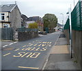
Forge Road bus stop, Forgeside, Blaenavon
A view west along Forge Road. The large building next to a tree is the derelict former school http://www.geograph.org.uk/photo/2850050 on the corner of Oxford Terrace. The wall and green fence on the right are at the perimeter of an industrial area extending for about 600 metres along the north side of the residential part of Forgeside.
Image: © Jaggery
Taken: 15 Apr 2011
0.06 miles
10
Forge Road bungalows, Forgeside
The two semi-detached bungalows are on the corner of Forge Road and Clapham Terrace. http://www.geograph.org.uk/photo/2849804
Image: © Jaggery
Taken: 15 Apr 2011
0.06 miles


