IMAGES TAKEN NEAR TO
Barnfield Terrace, PONTYPOOL, NP4 9BS
Introduction
This page details the photographs taken nearby to Barnfield Terrace, NP4 9BS by members of the Geograph project.
The Geograph project started in 2005 with the aim of publishing, organising and preserving representative images for every square kilometre of Great Britain, Ireland and the Isle of Man.

There are currently over 7.5m images from over14,400 individuals and you can help contribute to the project by visiting https://www.geograph.org.uk
Image Map
Images are licensed for reuse under creativecommons.org/licenses/by-sa/2.0
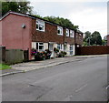
Notes
- Clicking on the map will re-center to the selected point.
- The higher the marker number, the further away the image location is from the centre of the postcode.
Image Listing (459 Images Found)
Images are licensed for reuse under creativecommons.org/licenses/by-sa/2.0
Image
Details
Distance
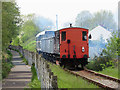
1
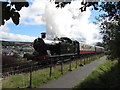
Pontypool & Blaenavon Railway
Ex-Great Western 0-6-2T No. 5637 heads north from Blaenavon High Level station during the railway's steam gala.
Image: © Gareth James
Taken: 12 Sep 2015
0.06 miles
2
Hawthorn Leslie No. 2 in Blaenavon
Hawthorn Leslie 0-4-0ST No. 2 is seen soon after departing Blaenavon High Level station during the Pontypool & Blaenavon Railway's steam gala.
Image: © Gareth James
Taken: 10 Sep 2023
0.07 miles
3
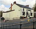
Queen Victoria Inn, Blaenavon
Located on Prince Street, near the post office. http://www.geograph.org.uk/photo/1854049
One of about a dozen pubs in the town, a survivor from the 50 or so that were open in the late 19th century.
Image: © Jaggery
Taken: 12 May 2010
0.07 miles
4
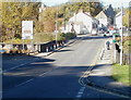
Northern end of Varteg Road, Blaenavon
At the end of its descent from moorland http://www.geograph.org.uk/photo/2128543 into Blaenavon, the B4246, here named Varteg Road, is renamed Prince Street ahead, at the crossroads where the vehicles are.
Image: © Jaggery
Taken: 25 Oct 2010
0.07 miles
5
Pontypool & Blaenavon Railway
Class 31 diesel locomotive No. D5627 makes a smokey departure from Blaenavon High Level station with a train of coal wagons.
Image: © Gareth James
Taken: 26 May 2019
0.08 miles
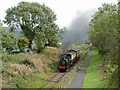
7
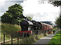
Pontypool & Blaenavon Railway
Visiting Super D class locomotive No. 49395, built in Crewe in 1921, heads north from Blaenavon High Level station at the Railway's 30th Anniversary Gala.
Image: © Gareth James
Taken: 14 Sep 2013
0.09 miles
8
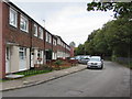
Curwood houses, Blaenavon
Connecting with the B4246, Curwood is a dead-end street on the south bank of a river, the Afon Lwyd.
The street ends a few metres behind the cars. The fence on the right is at the river's edge.
Image: © Jaggery
Taken: 20 Sep 2015
0.09 miles
9
Row of houses, Curwood, Blaenavon
Connecting with the B4246, Curwood is a dead-end street on the south bank of a river, the Afon Lwyd.
Image: © Jaggery
Taken: 20 Sep 2015
0.10 miles
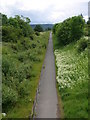
10
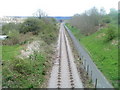
Railway line and footpath, Forgeside
The view from a bridge http://www.geograph.org.uk/photo/2363764 along the single-track line of the heritage Pontypool & Blaenavon Railway, looking in the direction of their SE terminus at Blaenavon (High Level) station.
Image: © Jaggery
Taken: 15 Apr 2011
0.10 miles