IMAGES TAKEN NEAR TO
Curwood, PONTYPOOL, NP4 9BL
Introduction
This page details the photographs taken nearby to Curwood, NP4 9BL by members of the Geograph project.
The Geograph project started in 2005 with the aim of publishing, organising and preserving representative images for every square kilometre of Great Britain, Ireland and the Isle of Man.

There are currently over 7.5m images from over14,400 individuals and you can help contribute to the project by visiting https://www.geograph.org.uk
Image Map
Images are licensed for reuse under creativecommons.org/licenses/by-sa/2.0
Notes
- Clicking on the map will re-center to the selected point.
- The higher the marker number, the further away the image location is from the centre of the postcode.
Image Listing (604 Images Found)
Images are licensed for reuse under creativecommons.org/licenses/by-sa/2.0
Image
Details
Distance
2
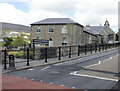
Blaenavon World Heritage Centre
Blaenavon World Heritage Centre, the first in the UK, opened in March 2008. It tells the story of Blaenavon and its people during the huge changes in the area during the Industrial Revolution.
Housed within two refurbished historic buildings on Church Road, the centre's visitor facilities include exhibitions, a cafe and a tourist information centre.
The buildings were originally St Peter's Church School, which opened in 1816. Unlike most schools of the era, it provided free education (for ironworkers' children up to the age of 12).
Image: © Jaggery
Taken: 12 May 2010
0.05 miles
3
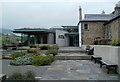
Entrance to Blaenavon World Heritage Centre
The Centre http://www.geograph.org.uk/photo/1855086 is located on Church Road.
Image: © Jaggery
Taken: 16 Sep 2011
0.05 miles
4
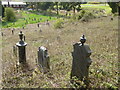
Weed-choked graveyard adjacent to World Heritage Centre, Blaenavon
Viewed from the perimeter wall at the Heritage Centre. http://www.geograph.org.uk/photo/2603886 My first thought was that this was part of the churchyard of the nearby St Peter's Church http://www.geograph.org.uk/photo/2497190 but graves nearer the church are well tended, so perhaps this overgrown graveyard was part of a church site now occupied by the heritage centre.
Image: © Jaggery
Taken: 16 Sep 2011
0.05 miles
5
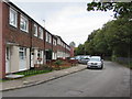
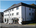
Curwood houses, Blaenavon
Connecting with the B4246, Curwood is a dead-end street on the south bank of a river, the Afon Lwyd.
The street ends a few metres behind the cars. The fence on the right is at the river's edge.
Image: © Jaggery
Taken: 20 Sep 2015
0.06 miles
6
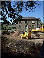
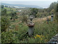
World Heritage Centre, Blaenavon
Landscaping improvements for the World Heritage Centre underway
Image: © Kev Griffin
Taken: 5 Oct 2007
0.06 miles
7
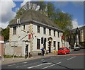
Blaenavon Post Office in May 2010
Located in Prince Street, purpose built in 1937 as a main sorting office. It housed the telephone exchange, sorting rooms, telephone boxes, offices and strong rooms.
The building, now Grade II listed, has a steep pitched roof of hand-crafted stone tiles, a marble plinth and sandstone frontage. Inside, much remains of the original woodwork.
Still in use as a post office ; other items and services available include holiday flat rental, a selection of food and drinks (including local ice creams), gifts and cards.
UPDATE. This post office closed down in early 2015. Blaenavon's
only post office is now inside this http://www.geograph.org.uk/photo/4667111 nearby shop.
Image: © Jaggery
Taken: 12 May 2010
0.07 miles
8
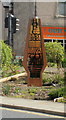
Hope is not broken, Blaenavon
This sculpture, created in 2009 at the Community Garden in Prince Street, is in the shape of a blast furnace. It is made of a corten steel frame filled with toughened coloured glass. Corten steel initially rusts to a warm reddish colour, then resists any further corrosion.
Blaenavon's motto "Hope is not broken" is shown in black lettering in English and Welsh. The motto is based on the coat of arms of the Kennard family, who were leading industrialists in Blaenavon in the 19th century.
Image: © Jaggery
Taken: 12 May 2010
0.07 miles
9
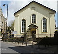
Horeb Baptist Church, Blaenavon
Located on the corner of Church Road and High Street. Built in 1807, rebuilt or modified several times in the 19th century. The year shown on the building is 1862. The name on the building shows 'Chapel' whereas the name on the sign to the left of the entrance shows 'Church'. The building was Grade II listed in 1995.
Image: © Jaggery
Taken: 12 May 2010
0.07 miles
10
Co-operative Food, Blaenavon
Located on Ivor Street. Open 7am-10pm Mondays-Saturdays, 8am-10pm on Sundays.
The post office http://www.geograph.org.uk/photo/1854049 is at the left edge of the photo.
Image: © Jaggery
Taken: 25 Oct 2010
0.07 miles