IMAGES TAKEN NEAR TO
Station Terrace, PONTYPOOL, NP4 9BA
Introduction
This page details the photographs taken nearby to Station Terrace, NP4 9BA by members of the Geograph project.
The Geograph project started in 2005 with the aim of publishing, organising and preserving representative images for every square kilometre of Great Britain, Ireland and the Isle of Man.

There are currently over 7.5m images from over14,400 individuals and you can help contribute to the project by visiting https://www.geograph.org.uk
Image Map
Images are licensed for reuse under creativecommons.org/licenses/by-sa/2.0
Notes
- Clicking on the map will re-center to the selected point.
- The higher the marker number, the further away the image location is from the centre of the postcode.
Image Listing (640 Images Found)
Images are licensed for reuse under creativecommons.org/licenses/by-sa/2.0
Image
Details
Distance
1
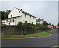
White semis above a Blaenavon corner
Semi-detached houses set above the corner of Varteg Road and Curwood.
Image: © Jaggery
Taken: 9 Jul 2020
0.00 miles
2
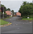
Junction of Curwood and Varteg Road, Blaenavon
Looking west along Curwood, a cul-de-sac on a bank of a river, the Afon Lwyd.
Image: © Jaggery
Taken: 9 Jul 2020
0.01 miles
3
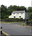
White house amid greenery, Blaenavon
Viewed across the B4246 Varteg Road in July 2020.
Image: © Jaggery
Taken: 9 Jul 2020
0.01 miles
4
Curwood cold calling control zone notice, Blaenavon
The notice is on a lamppost at the SE end of the street name Curwood, facing the B4246 junction.
http://www.geograph.org.uk/photo/4325336 to a photo taken elsewhere in Torfaen which gives details of a cold calling control zone.
Image: © Jaggery
Taken: 20 Sep 2015
0.01 miles
5
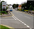
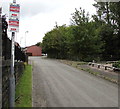
Junction ahead, Blaenavon
The sign alongside the B4246 is on the corner of Curwood at the edge of the bridge over the infant Afon Lwyd. Stay on the B4246 for the centre of Blaenavon heritage town, industrial estates, Abergavenny and Brynmawr or turn right onto the A4043 http://www.geograph.org.uk/photo/4669584 for Pontypool.
Image: © Jaggery
Taken: 20 Sep 2015
0.01 miles
6
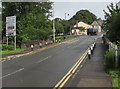
Directions sign near a river bridge, Varteg Road, Blaenavon
Near the bridge carrying the B4246 Varteg Road over the Afon Lwyd.
Ahead for the centre of Blaenavon and for Abergavenny and Brynmawr.
Turn right for the A4043 Cwmavon Road.
Image: © Jaggery
Taken: 9 Jul 2020
0.01 miles
7
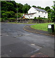
Dark green cabinet, Bridge Street, Blaenavon
Telecoms cabinet near the corner of the B4246 Varteg Road viewed in July 2020.
A May 2011 Google Street View of this corner shows no cabinet here.
The bench shown in the view has been removed.
Image: © Jaggery
Taken: 9 Jul 2020
0.02 miles
8
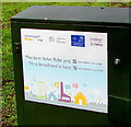
Fibre broadband is here, Bridge Street, Blaenavon
The text on the notice on this https://www.geograph.org.uk/photo/6557700 cabinet is in Welsh and English.
Image: © Jaggery
Taken: 9 Jul 2020
0.02 miles
9
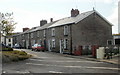
Mary Street, Blaenavon
Houses on the south side of the street, viewed from near the Broad Street end.
Image: © Jaggery
Taken: 12 May 2010
0.02 miles
10
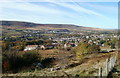
Blaenavon viewed from high ground
The view to the SW across Blaenavon from high ground at Upper Coedcae.
Image: © Jaggery
Taken: 25 Oct 2010
0.02 miles