IMAGES TAKEN NEAR TO
Avon Road, PONTYPOOL, NP4 9AU
Introduction
This page details the photographs taken nearby to Avon Road, NP4 9AU by members of the Geograph project.
The Geograph project started in 2005 with the aim of publishing, organising and preserving representative images for every square kilometre of Great Britain, Ireland and the Isle of Man.

There are currently over 7.5m images from over14,400 individuals and you can help contribute to the project by visiting https://www.geograph.org.uk
Image Map
Images are licensed for reuse under creativecommons.org/licenses/by-sa/2.0
Notes
- Clicking on the map will re-center to the selected point.
- The higher the marker number, the further away the image location is from the centre of the postcode.
Image Listing (564 Images Found)
Images are licensed for reuse under creativecommons.org/licenses/by-sa/2.0
Image
Details
Distance
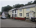
1
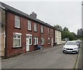
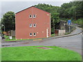
Row of houses, Avon Road, Blaenavon
On a bank of a river, the Afon Lwyd, here about 300 metres (c985 ft) above mean sea level.
Image: © Jaggery
Taken: 9 Sep 2020
0.01 miles
2
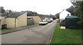
Avon Road, Blaenavon
A dark green electricity substation https://www.geograph.org.uk/photo/6598254 is on the right.
Image: © Jaggery
Taken: 9 Sep 2020
0.01 miles
3
Riverside Drive, Blaenavon
Viewed across Bridge Street. The large bilingual name signs show that Riverside Drive leads to Horseshoe Row, with the same information in Welsh. The railings and trees on the left are alongside an infant river, the Afon Lwyd, here about a 1 kilometre from its source.
What is now Riverside Drive used to be the site of Blaenavon (Low Level) Station http://www.geograph.org.uk/photo/1825303 which closed at the end of April 1962.
Image: © Jaggery
Taken: 2 Sep 2016
0.02 miles
4
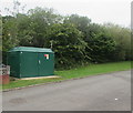
Dark green cabinet, Avon Road, Blaenavon
The cabinet is a Western Power Distribution electricity substation.
Its identifier is AVON RD BLAENAVON S/S 53-2767
Image: © Jaggery
Taken: 9 Sep 2020
0.02 miles
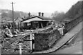
5
Blaenavon (low level) railway station (site), Monmouthshire
Opened in 1854 on the Great Western Railway's line from Pontypool, which carried passengers as far as here. The station closed in 1962.
View south east along the trackbed over the former level crossing towards Cwm Avon and Pontypool. The station area has now been completely redeveloped.
Image: © Nigel Thompson
Taken: 18 Aug 2012
0.03 miles
6
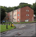
Three-storey housing, Riverside Drive, Blaenavon
Riverside Drive is on the south bank of the Afon Lwyd.
Image: © Jaggery
Taken: 9 Jul 2020
0.03 miles
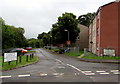
7
Junction of three roads, Blaenavon
Avon Road is on the right. Ahead for Brynavon. Bridge Street on the left leads to the B4246 Varteg Road.
Image: © Jaggery
Taken: 9 Sep 2020
0.04 miles
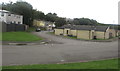
8
Blaenavon (Low Level) Station (remains)
View SE, towards Pontypool and Newport; terminus of GW line from Newport via Pontypool, closed completely 30/4/62. The station seems quite intact three years later.
Image: © Ben Brooksbank
Taken: 5 Apr 1965
0.04 miles
9
Avon Road houses, Blaenavon
On a bank of a river, the Afon Lwyd, here about 300 metres (c985 ft) above mean sea level.
Image: © Jaggery
Taken: 9 Sep 2020
0.04 miles
10
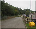
West along Avon Road, Blaenavon
Viewed from the corner of Brynavon. The trees and bushes are on a bank of
a river, the Afon Lwyd, here about 300 metres (c985 ft) above mean sea level.
Image: © Jaggery
Taken: 9 Sep 2020
0.04 miles