IMAGES TAKEN NEAR TO
Lower Hill Street, PONTYPOOL, NP4 9AR
Introduction
This page details the photographs taken nearby to Lower Hill Street, NP4 9AR by members of the Geograph project.
The Geograph project started in 2005 with the aim of publishing, organising and preserving representative images for every square kilometre of Great Britain, Ireland and the Isle of Man.

There are currently over 7.5m images from over14,400 individuals and you can help contribute to the project by visiting https://www.geograph.org.uk
Image Map
Images are licensed for reuse under creativecommons.org/licenses/by-sa/2.0
Notes
- Clicking on the map will re-center to the selected point.
- The higher the marker number, the further away the image location is from the centre of the postcode.
Image Listing (714 Images Found)
Images are licensed for reuse under creativecommons.org/licenses/by-sa/2.0
Image
Details
Distance
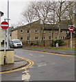
1
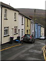
Down Lower Hill Street, Blaenavon
Lower Hill Street descends towards Mary Street and the A4043 Cwmavon Road.
Image: © Jaggery
Taken: 5 Dec 2019
0.01 miles
2
Lower Hill Street, Blaenavon
Lower Hill Street descends towards the A4043 Cwmavon Road. Viewed from the junction of Old William Street and New William Street. The right turn into Mary Street http://www.geograph.org.uk/photo/3652704 is just out of shot ahead.
Image: © Jaggery
Taken: 14 Sep 2013
0.01 miles
3
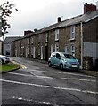
Row of stone houses, Mary Street, Blaenavon
Located between Broad Street and Lower Hill Street (ahead).
Image: © Jaggery
Taken: 9 Jul 2020
0.02 miles
4
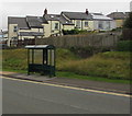
Dark green bus shelter alongside the A4043 Cwmavon Road, Blaenavon
In September 2020 this is a stop on bus route 30 from Blaenavon to Cwmbran via Pontypool operated by Phil Anslow Travel.
Image: © Jaggery
Taken: 9 Sep 2020
0.02 miles
5
No Entry signs at the eastern end of Old William Street, Blaenavon
Facing the western end of New William Street.
Image: © Jaggery
Taken: 5 Dec 2019
0.02 miles
6
Warning signs at the western end of New William Street, Blaenavon
A roundabout and two-way traffic are ahead. A small yellow Neighbourhood Watch Area sign is below the two warning signs.
Image: © Jaggery
Taken: 5 Dec 2019
0.02 miles
7
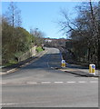
A4043 from Blaenavon towards Pontypool
The Keep Left signs are at the western end of the A4043, viewed across the B4246.
The A4043 is unusual in being an A road which starts from a B road.
Image: © Jaggery
Taken: 27 Feb 2020
0.03 miles
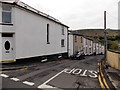
8

Former Butler Central Garage for sale, Blaenavon
Located on Market Street. The estate agents' sign on the wall shows
"For sale garage/workshop with 2 bed flat." Bed is short for bedroom in this context.
Image: © Jaggery
Taken: 25 Oct 2010
0.03 miles
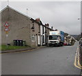
9
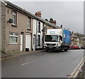
DX lorry, New William Street, Blaenavon
Text on the side of the lorry shows that DX = DELIVERED EXACTLY.
Image: © Jaggery
Taken: 5 Dec 2019
0.03 miles
10
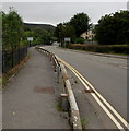
Metal barrier alongside Cwmavon Road, Blaenavon
On the south side of the A4043 Cwmavon Road on the approach to the B4246 junction.
Image: © Jaggery
Taken: 9 Sep 2020
0.03 miles