IMAGES TAKEN NEAR TO
The Park, PONTYPOOL, NP4 9AJ
Introduction
This page details the photographs taken nearby to The Park, NP4 9AJ by members of the Geograph project.
The Geograph project started in 2005 with the aim of publishing, organising and preserving representative images for every square kilometre of Great Britain, Ireland and the Isle of Man.

There are currently over 7.5m images from over14,400 individuals and you can help contribute to the project by visiting https://www.geograph.org.uk
Image Map
Images are licensed for reuse under creativecommons.org/licenses/by-sa/2.0
Notes
- Clicking on the map will re-center to the selected point.
- The higher the marker number, the further away the image location is from the centre of the postcode.
Image Listing (786 Images Found)
Images are licensed for reuse under creativecommons.org/licenses/by-sa/2.0
Image
Details
Distance
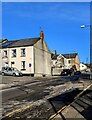
1
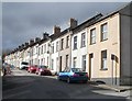
Lower Waun Street, Blaenavon
The north side of the street, viewed from the corner of High Street.
Image: © Jaggery
Taken: 3 Apr 2011
0.02 miles
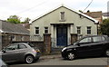
2
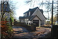
The Mews, The Park, Blaenavon
Detached house on private road.
Image: © M J Roscoe
Taken: 1 Dec 2022
0.03 miles
3
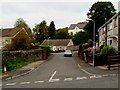
Park Gardens, Blaenavon
Cul-de-sac on the west side of Park Street.
Image: © Jaggery
Taken: 25 Sep 2015
0.03 miles
4
SE corner of a former primary school, Park Street, Blaenavon
Viewed in September 2015. This used to be St Peter's Church in Wales Primary School, one of the schools which were redundant after the opening of Blaenavon Heritage VC Primary School in 2012. Hillside Primary School and Hillside Nursery also closed. Pupils at all three transferred to the new school.
Image: © Jaggery
Taken: 25 Sep 2015
0.06 miles
5
Blue sky in winter, Blaenavon
Looking up High Street on January 17th 2023.
Image: © Jaggery
Taken: 17 Jan 2023
0.06 miles
6
Former school, Park Street, Blaenavon
In September 2015, metal sheets protect windows of the former St Peter's Church in Wales Primary School.
This was one of the schools which were redundant after the opening of Blaenavon Heritage VC Primary School in 2012. Hillside Primary School and Hillside Nursery also closed. Pupils at all three transferred to the new school.
Image: © Jaggery
Taken: 25 Sep 2015
0.06 miles
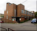
7
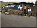
Blaenavon O.A.P. Welfare Hall, Blaenavon
On the west side of Park Street, near the Park Gardens junction.
O.A.P = Old Age Pensioners, people who are usually referred to as Senior Citizens in 2015.
Image: © Jaggery
Taken: 25 Sep 2015
0.06 miles
8
Rear of Blaenavon House (The Beeches)
Derelict Georgian mansion Image; the structures in the foreground are later extensions.
Image: © M J Roscoe
Taken: 1 Dec 2022
0.06 miles
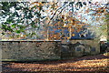
9
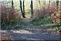
Track down through beech woodland
The track goes down from a private road towards Church Road.
Image: © M J Roscoe
Taken: 1 Dec 2022
0.06 miles
10
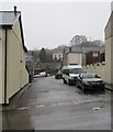
Unnamed side street on the west side of High Street, Blaenavon
From High Street to Park Street.
Image: © Jaggery
Taken: 12 Dec 2019
0.07 miles