IMAGES TAKEN NEAR TO
Park Street, PONTYPOOL, NP4 9AA
Introduction
This page details the photographs taken nearby to Park Street, NP4 9AA by members of the Geograph project.
The Geograph project started in 2005 with the aim of publishing, organising and preserving representative images for every square kilometre of Great Britain, Ireland and the Isle of Man.

There are currently over 7.5m images from over14,400 individuals and you can help contribute to the project by visiting https://www.geograph.org.uk
Image Map
Images are licensed for reuse under creativecommons.org/licenses/by-sa/2.0
Notes
- Clicking on the map will re-center to the selected point.
- The higher the marker number, the further away the image location is from the centre of the postcode.
Image Listing (763 Images Found)
Images are licensed for reuse under creativecommons.org/licenses/by-sa/2.0
Image
Details
Distance
1
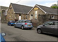
Busy Bees Nursery & Kids' Club, Park Street, Blaenavon
A metal plate http://www.geograph.org.uk/photo/4673572 on the left side of the buildings now occupied by Busy Bees shows that this was originally Wesleyan Day Schools (1871).
Image: © Jaggery
Taken: 25 Sep 2015
0.01 miles
2
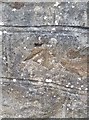
Ordnance Survey Cut Mark
This worn OS cut mark can be found on the wall NW side of Park Street. It marks a point 325.837m above mean sea level.
Image: © Adrian Dust
Taken: 18 Aug 2018
0.01 miles
3
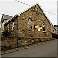
Busy Bees, Park Street, Blaenavon
In September 2015 this is Busy Bees Nursery & Kids' Club.
The metal plate at the top of the building shows its original use: WESLEYAN DAY SCHOOLS 1871.
http://www.geograph.org.uk/photo/4673580 to another view of Busy Bees.
Image: © Jaggery
Taken: 25 Sep 2015
0.02 miles
4
Blaenavon O.A.P. Welfare Hall, Blaenavon
On the west side of Park Street, near the Park Gardens junction.
O.A.P = Old Age Pensioners, people who are usually referred to as Senior Citizens in 2015.
Image: © Jaggery
Taken: 25 Sep 2015
0.02 miles
5
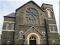
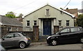
Park Street Methodist Church, Blaenavon
Built in 1885 to the design of architect John Wills of Derby, the chapel is built in the Romanesque/Lombardic style with a gable-entry plan, a large arch in the facade, integral tower and wheel window.
Image: © Ann
Taken: 30 Apr 2011
0.02 miles
6
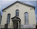
Horeb Baptist Chapel, Blaenavon
Grade II listed building, built in 1862 for the Baptists at a cost of £1300, this was the second Horeb Chapel to be built in Blaenavon.
Image: © Ann
Taken: 30 Apr 2011
0.02 miles
7
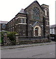
South side of Park Street Methodist Church, Blaenavon
Inscriptions above the doorway show WESLEYAN METHODIST CHURCH and the years 1885 and 1920.
http://www.geograph.org.uk/photo/1855072 to a corner view.
Image: © Jaggery
Taken: 25 Sep 2015
0.02 miles
8
Park Street Methodist Church, Blaenavon
The church is part of the Gwent Hills and Vales Methodist Circuit.
Inscriptions above the doorway show WESLEYAN METHODIST CHURCH and the years 1885 and 1920.
Image: © Jaggery
Taken: 10 May 2018
0.02 miles
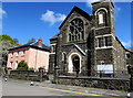
9
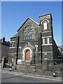
Park Street methodist Church, Blaenavon
Designed by John Wills. Built 1885-6.
Image: © Jonathan Thacker
Taken: 18 Sep 2024
0.02 miles
10
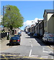
Up High Street, Blaenavon
High Street ascends from Church Road. This High Street is mostly residential -
the main shopping/commercial street in Blaenavon is nearby Broad Street.
Image: © Jaggery
Taken: 10 May 2018
0.02 miles