IMAGES TAKEN NEAR TO
Cwmavon Road, NP4 8XL
Introduction
This page details the photographs taken nearby to Cwmavon Road, NP4 8XL by members of the Geograph project.
The Geograph project started in 2005 with the aim of publishing, organising and preserving representative images for every square kilometre of Great Britain, Ireland and the Isle of Man.

There are currently over 7.5m images from over14,400 individuals and you can help contribute to the project by visiting https://www.geograph.org.uk
Image Map
Images are licensed for reuse under creativecommons.org/licenses/by-sa/2.0
Notes
- Clicking on the map will re-center to the selected point.
- The higher the marker number, the further away the image location is from the centre of the postcode.
Image Listing (74 Images Found)
Images are licensed for reuse under creativecommons.org/licenses/by-sa/2.0
Image
Details
Distance
2
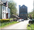
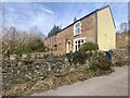
Cwmavon Works
Viewed from the edge of Cwmavon Road (A4043). A sign at the entrance shows that the works are (April 2011) the factory and head office of two firms: EMC (Extrusion & Moulding Compounds Ltd) and Capital Valley Plastics. The reception building is on the left.
Image: © Jaggery
Taken: 28 Apr 2011
0.06 miles
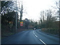
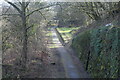
3
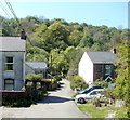
Llanover Lane, Cwmavon
Viewed across Cwmavon Road (A4043). Llanover Lane descends into the valley of the Afon Lwyd.
A sign on the left shows that there is a 3 tonne weight limit on the river bridge ahead.
Image: © Jaggery
Taken: 28 Apr 2011
0.06 miles
4
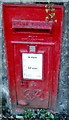
Wall-mounted George VI postbox, Cwmavon
Located at the edge of a bus stop http://www.geograph.org.uk/photo/3022536 on the west side of Cwmavon Road.
Image: © Jaggery
Taken: 28 Apr 2011
0.06 miles
5
Bus stop, postbox and litter bin, Cwmavon
Located on the west side of Cwmavon Road, opposite the Llanover Lane junction. http://www.geograph.org.uk/photo/3022548
The wall postbox, mounted at street level, is from the reign of King George VI. http://www.geograph.org.uk/photo/3022540
Image: © Jaggery
Taken: 28 Apr 2011
0.06 miles
6
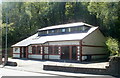
Cwmavon Village Hall
Located alongside the A4043.
In the mid 19th century a Wesleyan chapel was built here. A Sunday School was added in the 1920s.
In 1972 the Sunday School was bought by the people of the village for use as a community centre.
Early in 2007, the community centre was demolished. It was replaced by this new village hall which opened in spring 2008.
Image: © Jaggery
Taken: 28 Apr 2011
0.06 miles
8
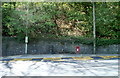
Along Llanover Lane, Cwmavon
Looking west towards a stone bridge across the Afon Lwyd.
Image: © Jaggery
Taken: 28 Apr 2011
0.09 miles
9
Remains of Varteg Railway Station
The overgrown platform and derelict building Image are on the right of the former LNWR trackbed, now part of the Afon Lwyd Trail, NCR 492. Viewed from Shop Road Bridge.
Image: © M J Roscoe
Taken: 25 Feb 2022
0.09 miles
10
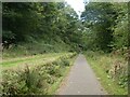
NCN492 passing former Varteg railway station
Image: © David Smith
Taken: 26 Sep 2021
0.09 miles