IMAGES TAKEN NEAR TO
Cwmavon, PONTYPOOL, NP4 8XF
Introduction
This page details the photographs taken nearby to NP4 8XF by members of the Geograph project.
The Geograph project started in 2005 with the aim of publishing, organising and preserving representative images for every square kilometre of Great Britain, Ireland and the Isle of Man.

There are currently over 7.5m images from over14,400 individuals and you can help contribute to the project by visiting https://www.geograph.org.uk
Image Map
Images are licensed for reuse under creativecommons.org/licenses/by-sa/2.0
Notes
- Clicking on the map will re-center to the selected point.
- The higher the marker number, the further away the image location is from the centre of the postcode.
Image Listing (47 Images Found)
Images are licensed for reuse under creativecommons.org/licenses/by-sa/2.0
Image
Details
Distance
1
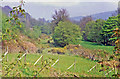
Site of Cwmavon (Mon./Gwent) station, 1988
View northward, towards Blaenavon (Low Level) station, ex-GWR Newport - Pontypool - Blaenavon (Eastern Valleys) line. The station and line had been closed from Pontypool (Crane St.) since 30/4/62. The view is up the Cwmavon valley to Mynydd Garw-Fawr (1,635 ft.).
Image: © Ben Brooksbank
Taken: 8 May 1988
0.03 miles
2
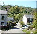
Along Llanover Lane, Cwmavon
Looking west towards a stone bridge across the Afon Lwyd.
Image: © Jaggery
Taken: 28 Apr 2011
0.05 miles
3
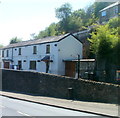
The Old Railway Cottage, Cwmavon
I was inclined to doubt the accuracy of the first reference I consulted, which named this roadside property as Old Railway Cottage. However, another source confirmed its name, and a 1940s map shows that Cwmavon (Mon) Halt railway station was a few metres away. The station closed in 1962.
The house on high ground is in Snail Creep Terrace.
Image: © Jaggery
Taken: 28 Apr 2011
0.06 miles
4
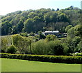
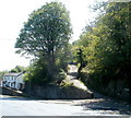
Hillside view, Cwmavon
Viewed from the eastern end of Llanover Lane looking towards and beyond Cwmavon Road.
Image: © Jaggery
Taken: 28 Apr 2011
0.06 miles
5
Snail Creep Terrace, Cwmavon
Viewed across Cwmavon Road. Snail Creep Terrace on the right begins a steep climb up to Varteg. http://www.geograph.org.uk/photo/1855978 to the Varteg end of Snail Creep Terrace.
Image: © Jaggery
Taken: 28 Apr 2011
0.06 miles
6
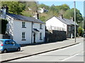
Cwmavon Road cottages, Cwmavon
Nearest the camera is The Cottage. Further away are Grove Cottage and Little Grove Cottage.
Image: © Jaggery
Taken: 28 Apr 2011
0.07 miles
7
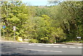
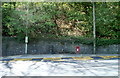
Llanover Lane, Cwmavon
Viewed across Cwmavon Road (A4043). Llanover Lane descends into the valley of the Afon Lwyd.
A sign on the left shows that there is a 3 tonne weight limit on the river bridge ahead.
Image: © Jaggery
Taken: 28 Apr 2011
0.08 miles
8
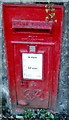
Wall-mounted George VI postbox, Cwmavon
Located at the edge of a bus stop http://www.geograph.org.uk/photo/3022536 on the west side of Cwmavon Road.
Image: © Jaggery
Taken: 28 Apr 2011
0.08 miles
9
Bus stop, postbox and litter bin, Cwmavon
Located on the west side of Cwmavon Road, opposite the Llanover Lane junction. http://www.geograph.org.uk/photo/3022548
The wall postbox, mounted at street level, is from the reign of King George VI. http://www.geograph.org.uk/photo/3022540
Image: © Jaggery
Taken: 28 Apr 2011
0.08 miles
10
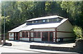
Cwmavon Village Hall
Located alongside the A4043.
In the mid 19th century a Wesleyan chapel was built here. A Sunday School was added in the 1920s.
In 1972 the Sunday School was bought by the people of the village for use as a community centre.
Early in 2007, the community centre was demolished. It was replaced by this new village hall which opened in spring 2008.
Image: © Jaggery
Taken: 28 Apr 2011
0.08 miles