IMAGES TAKEN NEAR TO
Forge Row, PONTYPOOL, NP4 8UU
Introduction
This page details the photographs taken nearby to Forge Row, NP4 8UU by members of the Geograph project.
The Geograph project started in 2005 with the aim of publishing, organising and preserving representative images for every square kilometre of Great Britain, Ireland and the Isle of Man.

There are currently over 7.5m images from over14,400 individuals and you can help contribute to the project by visiting https://www.geograph.org.uk
Image Map
Images are licensed for reuse under creativecommons.org/licenses/by-sa/2.0
Notes
- Clicking on the map will re-center to the selected point.
- The higher the marker number, the further away the image location is from the centre of the postcode.
Image Listing (28 Images Found)
Images are licensed for reuse under creativecommons.org/licenses/by-sa/2.0
Image
Details
Distance
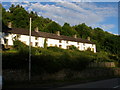
2
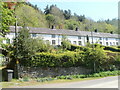
Cwmavon House & Forge Row
Cwmavon House (top left) is a late Georgian house built for the ironmaster of Varteg Forge. Forge Row of six grade II* listed cottages, originally twelve built in the early 1800s for ironworkers, is the finest surviving in situ terrace of industrial housing in South Wales. Viewed from NCR 492.
Image: © M J Roscoe
Taken: 25 Feb 2022
0.02 miles
3
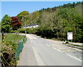
A view NE along the A4043, Cwmavon
Cwmavon Road (A4043) passes the entrance on the right to Cwmavon Works. http://www.geograph.org.uk/photo/3022475
The row of white houses is Grade II* listed Forge Row Cottages. http://www.geograph.org.uk/photo/3022438
Image: © Jaggery
Taken: 28 Apr 2011
0.03 miles
4
Side view of Grade II* listed Forge Row Cottages, Cwmavon
Set back from and above the main road (A4043) through Cwmavon.
Forge Row was built c 1804-1806 for workmen at the nearby Varteg Forge.
The original 12 houses were later converted to 6 houses.
Each house is individually Grade II* listed.
Image: © Jaggery
Taken: 28 Apr 2011
0.03 miles
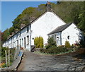
5
Grade II* listed Forge Row Cottages, Cwmavon
Set back from and above the main road (A4043) through Cwmavon.
Forge Row was built c 1804-1806 for workmen at the nearby Varteg Forge.
The original 12 houses were later converted to 6 houses.
Each house is individually Grade II* listed.
Image: © Jaggery
Taken: 28 Apr 2011
0.03 miles
6
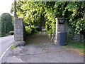
Gateway to Cwmavon House with the A4043 running to the side
Image: © Carol Rose
Taken: 16 Jun 2007
0.05 miles
7
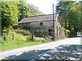
Former Cwmavon Cottage, Cwmavon
Now fenced off and derelict, located alongside the main road through Cwmavon, the A4043.
Image: © Jaggery
Taken: 28 Apr 2011
0.05 miles
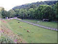
9
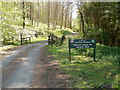
No vehicles allowed in Blaenavon Community Woodland
The sign is at the entrance to the southern part of the community woodland, near Forge Row Cottages http://www.geograph.org.uk/photo/3022445 in Cwmavon.
Image: © Jaggery
Taken: 28 Apr 2011
0.09 miles
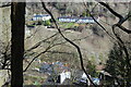
10
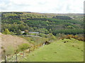
The view ENE from Varteg Incline
Spectacular scenery seen from the Varteg Incline viewing area. http://www.geograph.org.uk/photo/1855738
The row of white houses is Forge Row, forge workers' cottages in Cwmavon built c1804. A larger house to the left of the row, between trees, is Cwmavon House, where the forge manager lived.
Image: © Jaggery
Taken: 12 May 2010
0.09 miles