IMAGES TAKEN NEAR TO
Varteg Terrace, PONTYPOOL, NP4 8UR
Introduction
This page details the photographs taken nearby to Varteg Terrace, NP4 8UR by members of the Geograph project.
The Geograph project started in 2005 with the aim of publishing, organising and preserving representative images for every square kilometre of Great Britain, Ireland and the Isle of Man.

There are currently over 7.5m images from over14,400 individuals and you can help contribute to the project by visiting https://www.geograph.org.uk
Image Map
Images are licensed for reuse under creativecommons.org/licenses/by-sa/2.0
Notes
- Clicking on the map will re-center to the selected point.
- The higher the marker number, the further away the image location is from the centre of the postcode.
Image Listing (66 Images Found)
Images are licensed for reuse under creativecommons.org/licenses/by-sa/2.0
Image
Details
Distance
1
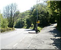
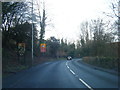
Junction of Shop Road and Cwmavon Road, Cwmavon
Shop Road on the right ascends towards Varteg.
Image: © Jaggery
Taken: 28 Apr 2011
0.05 miles
2
Cwmavon Works
Viewed from the edge of Cwmavon Road (A4043). A sign at the entrance shows that the works are (April 2011) the factory and head office of two firms: EMC (Extrusion & Moulding Compounds Ltd) and Capital Valley Plastics. The reception building is on the left.
Image: © Jaggery
Taken: 28 Apr 2011
0.07 miles
3
Site of missing bridge over former railway near Varteg
Image: © Gareth James
Taken: 15 Oct 2011
0.07 miles
4
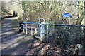
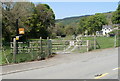
Stiles between cycle route and Shop Road
The bilingual sign give distances to Blaenavon and to Pontypool via NCR 492 on the former railway line. In the distance an abutment of the demolished bridge of the Varteg Incline tramway is just visible.
Image: © M J Roscoe
Taken: 25 Feb 2022
0.09 miles
6
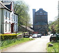
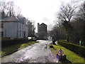
Entrance to Forge House, Cwmavon
Viewed from Cwmavon Road (A4043). Forge House, on the right, was built in the third quarter of the 19th century, probably at the same time that a file factory was established on the site, formerly the location of Varteg Forge.
Image: © Jaggery
Taken: 28 Apr 2011
0.09 miles
7
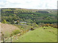
The view ENE from Varteg Incline
Spectacular scenery seen from the Varteg Incline viewing area. http://www.geograph.org.uk/photo/1855738
The row of white houses is Forge Row, forge workers' cottages in Cwmavon built c1804. A larger house to the left of the row, between trees, is Cwmavon House, where the forge manager lived.
Image: © Jaggery
Taken: 12 May 2010
0.09 miles
8
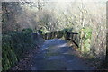
Shop Road Bridge
Looking at roadway, in poor condition on bridge over former LNWR trackbed Image, in direction of Cwmavon.
Image: © M J Roscoe
Taken: 25 Feb 2022
0.10 miles
9
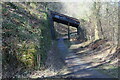
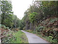
Shop Road Bridge over Afon Lwyd Trail
Metal road bridge over former LNWR branch line, now cycle track, NCR 492.
Image: © M J Roscoe
Taken: 25 Feb 2022
0.10 miles
10
Part of Cwmavon ironworks
An eyecatching sight beside the main road.
Image: © Jeremy Bolwell
Taken: 9 Feb 2014
0.10 miles