IMAGES TAKEN NEAR TO
Lasgarn Lane, PONTYPOOL, NP4 8TT
Introduction
This page details the photographs taken nearby to Lasgarn Lane, NP4 8TT by members of the Geograph project.
The Geograph project started in 2005 with the aim of publishing, organising and preserving representative images for every square kilometre of Great Britain, Ireland and the Isle of Man.

There are currently over 7.5m images from over14,400 individuals and you can help contribute to the project by visiting https://www.geograph.org.uk
Image Map
Images are licensed for reuse under creativecommons.org/licenses/by-sa/2.0
Notes
- Clicking on the map will re-center to the selected point.
- The higher the marker number, the further away the image location is from the centre of the postcode.
Image Listing (5 Images Found)
Images are licensed for reuse under creativecommons.org/licenses/by-sa/2.0
Image
Details
Distance
1
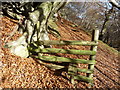
Stile in Beech woods
Walking on Beech leaves on a sunny winter day is great - they were crunching like fresh snow underfoot - and the root systems were embedded into the bedrock outcrops here.
Image: © Jeremy Bolwell
Taken: 18 Nov 2012
0.11 miles
2
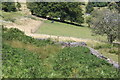
Footpath down from Lasgarn Lane
The yellow-topped signpost is next to a bracken covered stile; the public footpath goes down to the right between the two post and wire fences. The stone wall is the boundary of the open access land.
Image: © M J Roscoe
Taken: 7 Aug 2020
0.15 miles
3
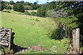
Field footpath
Public footpath on edge of field. Further south the path was blocked by a dense area of bracken laced with brambles and nettles!
Image: © M J Roscoe
Taken: 7 Aug 2020
0.17 miles
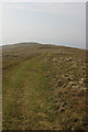
4
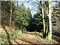
Track into forestry plantation
The path and track passes from open Beech woods into a mature, dense block of conifers.
Image: © Jeremy Bolwell
Taken: 18 Nov 2012
0.23 miles