IMAGES TAKEN NEAR TO
Mamhilad, PONTYPOOL, NP4 8RQ
Introduction
This page details the photographs taken nearby to NP4 8RQ by members of the Geograph project.
The Geograph project started in 2005 with the aim of publishing, organising and preserving representative images for every square kilometre of Great Britain, Ireland and the Isle of Man.

There are currently over 7.5m images from over14,400 individuals and you can help contribute to the project by visiting https://www.geograph.org.uk
Image Map
Images are licensed for reuse under creativecommons.org/licenses/by-sa/2.0
Notes
- Clicking on the map will re-center to the selected point.
- The higher the marker number, the further away the image location is from the centre of the postcode.
Image Listing (12 Images Found)
Images are licensed for reuse under creativecommons.org/licenses/by-sa/2.0
Image
Details
Distance
1
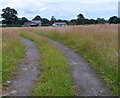
Twin tracks through a field near Mamhilad
Viewed from Croes y Pant Lane in rural Monmouthshire.
Image: © Jaggery
Taken: 20 Jul 2012
0.08 miles
2
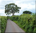
Tree at a bend in Croes y Pant Lane, Mamhilad
The location is about 200 metres SE of Old Abergavenny Road.
Image: © Jaggery
Taken: 20 Jul 2012
0.09 miles
3
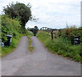
Access road to Vedw Farm, Mamhilad
From Croes y Pant Lane.
Image: © Jaggery
Taken: 20 Jul 2012
0.11 miles
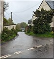
4
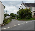
Junction of Old Abergavenny Road and Croes y Pant Lane, Mamhilad
Viewed across Old Abergavenny Road.
Croes y Pant Lane heads SE past The Horseshoe Inn http://www.geograph.org.uk/photo/3046889 on the right.
Image: © Jaggery
Taken: 20 Jul 2012
0.18 miles
5
SE along Croes-y-pant Lane, Mamhilad
From Old Abergavenny Road. The Horseshoe Inn https://www.geograph.org.uk/photo/7476913 is on the right.
Image: © Jaggery
Taken: 30 Apr 2023
0.18 miles
6
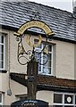
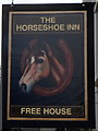
Horseshoe Inn name sign, Mamhilad, Monmouthshire
On the Old Abergavenny Road side https://www.geograph.org.uk/photo/7476913 of the inn on the corner of Croes-y-pant Lane.
Image: © Jaggery
Taken: 30 Apr 2023
0.18 miles
7
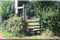
Stile opposite Croes-y-Pant Lane
Stile at road junction almost opposite the Horseshoe Inn. The left sign says, 'Trevithin 4.8 km', the other, 'Holy Well 1.6 km'.
Image: © M J Roscoe
Taken: 8 Aug 2020
0.20 miles
8
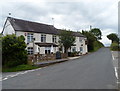
The Horseshoe Inn, Mamhilad
Located alongside Old Abergavenny Road, in a rural setting about a kilometre north of the village church. http://www.geograph.org.uk/photo/3046385
http://www.geograph.org.uk/photo/3046890 to the pub sign hanging from the wall at the far end of the building.
Image: © Jaggery
Taken: 20 Jul 2012
0.21 miles
9
Pub sign, The Horseshoe Inn, Mamhilad
This distinctive pub sign is a big improvement on its predecessor,
which merely showed the words The Horseshoe.
The pub http://www.geograph.org.uk/photo/3046889 is about a kilometre north of the centre of Mamhilad.
Image: © Jaggery
Taken: 20 Jul 2012
0.22 miles
10
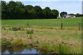
Fields below Bryn, from the Monmouthshire and Brecon Canal
Image: © David Martin
Taken: 18 Jul 2017
0.23 miles