IMAGES TAKEN NEAR TO
Coed Camlas, PONTYPOOL, NP4 8RP
Introduction
This page details the photographs taken nearby to Coed Camlas, NP4 8RP by members of the Geograph project.
The Geograph project started in 2005 with the aim of publishing, organising and preserving representative images for every square kilometre of Great Britain, Ireland and the Isle of Man.

There are currently over 7.5m images from over14,400 individuals and you can help contribute to the project by visiting https://www.geograph.org.uk
Image Map
Images are licensed for reuse under creativecommons.org/licenses/by-sa/2.0
Notes
- Clicking on the map will re-center to the selected point.
- The higher the marker number, the further away the image location is from the centre of the postcode.
Image Listing (172 Images Found)
Images are licensed for reuse under creativecommons.org/licenses/by-sa/2.0
Image
Details
Distance
1
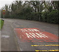
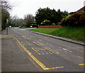
English/Welsh text on The Highway, New Inn
SLOW/ARAF is painted on the road surface on the approach to a bend. Ahead for the centre of New Inn.
Image: © Jaggery
Taken: 11 Apr 2018
0.03 miles
2
Reduce Speed Now/Arafwch Nawr, The Highway, New Inn
English/Welsh sign on the approach to a bend in The Highway and the Coed-y-Canddo Road junction.
Image: © Jaggery
Taken: 11 Apr 2018
0.03 miles
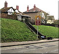
3
Steps up to houses, New Inn
From The Highway.
Image: © Jaggery
Taken: 11 Apr 2018
0.04 miles
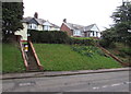
4

Panteg Cemetery Garden of Remembrance
The Garden of Remembrance is located near the entrance from The Highway, in the southwest part of the cemetery.
Image: © Jaggery
Taken: 17 Jan 2010
0.05 miles
5

SLOW/ARAF on The Highway, New Inn
English/Welsh text painted on the road surface. Ahead for the centre of New Inn.
Image: © Jaggery
Taken: 11 Apr 2018
0.05 miles
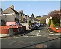
6
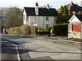
House on the corner of Coed-Y-Canddo Road and The Highway, New Inn
Looking down Coed-Y-Canddo Road towards the junction with The Highway.
Image: © Jaggery
Taken: 17 Jan 2010
0.06 miles
7
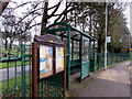
Coed Camlas bus shelter, New Inn
The shelter is between the perimeter fence of Panteg Cemetery and The Highway. The timetable on display on April 11th 2018 shows that the stop is for buses on two Stagecoach routes - 23 to Cwmbran bus station and 15 to Newport via Cwmbran bus station.
Image: © Jaggery
Taken: 11 Apr 2018
0.07 miles
8
Hillcrest Road, New Inn
Hillcrest Road, a short cul-de-sac, heads away from Coed-Y-Canddo Road towards the edge of Panteg Cemetery.
Image: © Jaggery
Taken: 17 Jan 2010
0.07 miles
9
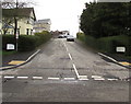
Coed-y-Canddo Road, New Inn
Coed-y-Canddo Road ascends from The Highway towards Hillcrest Road and Hand Farm Road.
Image: © Jaggery
Taken: 11 Apr 2018
0.07 miles
10
Bus stop near Coed-y-Canddo Road, New Inn
This stop for buses to the centre of Pontypool. The Coed-y-Canddo Road junction is on the right.
Image: © Jaggery
Taken: 11 Apr 2018
0.08 miles