IMAGES TAKEN NEAR TO
School Lane, PONTYPOOL, NP4 8RN
Introduction
This page details the photographs taken nearby to School Lane, NP4 8RN by members of the Geograph project.
The Geograph project started in 2005 with the aim of publishing, organising and preserving representative images for every square kilometre of Great Britain, Ireland and the Isle of Man.

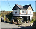
There are currently over 7.5m images from over14,400 individuals and you can help contribute to the project by visiting https://www.geograph.org.uk
Image Map
Images are licensed for reuse under creativecommons.org/licenses/by-sa/2.0
Notes
- Clicking on the map will re-center to the selected point.
- The higher the marker number, the further away the image location is from the centre of the postcode.
Image Listing (68 Images Found)
Images are licensed for reuse under creativecommons.org/licenses/by-sa/2.0
Image
Details
Distance
1
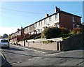
Hillrise, Abersychan
Houses on the north side of Hillrise viewed across Lower Harper's Road.
Image: © Jaggery
Taken: 25 Oct 2010
0.07 miles
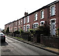
2
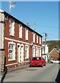
Houses at the eastern end of Viaduct Road, Victoria Village
Houses near the crossroads of Viaduct Road, Vicarage Lane, Harper's Road and Lower Harper's Road.
Image: © Jaggery
Taken: 25 Oct 2010
0.07 miles
3
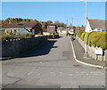
Eastern arm of Stoney Road, Victoria Village
Stoney Road climbs away from Viaduct Road. The western arm of Stoney Road is about 100 metres to the west, beyond the left edge of the photo. Victoria Village is a hamlet near Abersychan.
Image: © Jaggery
Taken: 25 Oct 2010
0.07 miles
4
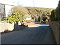
No pavements, Lower Harper's Road, Abersychan
There are no pavements alongside Lower Harper's Road in this section between Viaduct Road and Hillrise.
Image: © Jaggery
Taken: 25 Oct 2010
0.08 miles
5
Hair on Harpers, Abersychan
Unisex hair salon on Lower Harper's Road.
Image: © Jaggery
Taken: 25 Oct 2010
0.08 miles
6
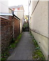
Path and steps from Manor Road to Manor Way, Abersychan
Extending for about 40 metres.
Image: © Jaggery
Taken: 29 Sep 2015
0.08 miles
7
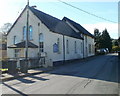
Victoria Village Methodist Church
Located on Viaduct Road. Victoria Village is a hamlet near Abersychan.
Image: © Jaggery
Taken: 25 Oct 2010
0.09 miles
8
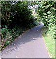
Unnamed side road in Abersychan
Viewed from the Incline Road end. The side road leads to the backs of a few Manor Road houses.
Image: © Jaggery
Taken: 29 Sep 2015
0.10 miles
10
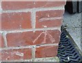
Ordnance Survey Cut Mark
This OS cut mark can be found on No25 Harpers Road. It marks a point 213.473m above mean sea level.
Image: © Adrian Dust
Taken: 25 Aug 2019
0.10 miles