IMAGES TAKEN NEAR TO
Harpers Road, PONTYPOOL, NP4 8QG
Introduction
This page details the photographs taken nearby to Harpers Road, NP4 8QG by members of the Geograph project.
The Geograph project started in 2005 with the aim of publishing, organising and preserving representative images for every square kilometre of Great Britain, Ireland and the Isle of Man.

There are currently over 7.5m images from over14,400 individuals and you can help contribute to the project by visiting https://www.geograph.org.uk
Image Map
Images are licensed for reuse under creativecommons.org/licenses/by-sa/2.0
Notes
- Clicking on the map will re-center to the selected point.
- The higher the marker number, the further away the image location is from the centre of the postcode.
Image Listing (48 Images Found)
Images are licensed for reuse under creativecommons.org/licenses/by-sa/2.0
Image
Details
Distance
1
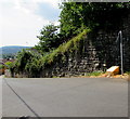
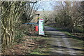
Yellow grit box alongside Harper's Road Garndiffaith
On the ascent towards this https://www.geograph.org.uk/photo/5848083 former railway bridge.
Image: © Jaggery
Taken: 19 Jul 2018
0.01 miles
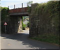
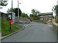
2
East side of a former railway bridge over Harper's Road, Garndiffaith
The former railway on the bridge is now part of National Cycle Network Route 492 from Cwmbran towards Brynmawr via Blaenavon.
Image: © Jaggery
Taken: 19 Jul 2018
0.02 miles
3
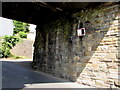
Visibility mirror on the wall of a former railway bridge, Garndiffaith
On the wall of this https://www.geograph.org.uk/photo/5848080 bridge over a bend in Harper's Road.
Image: © Jaggery
Taken: 19 Jul 2018
0.02 miles
4
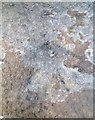
Ordnance Survey Rivet
This OS rivet can be found on the railway bridge, Harpers Road. It marks a point 255.782m above mean sea level.
Image: © Adrian Dust
Taken: 25 Aug 2019
0.02 miles
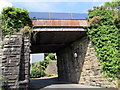
5
Former railway bridge over Harper's Road, Garndiffaith
Headroom of 4.4 metres (14' 6") is shown on the bridge over Harper's Road. The former railway on the bridge is now part of National Cycle Network Route 492 from Cwmbran towards Brynmawr via Blaenavon.
Image: © Jaggery
Taken: 19 Jul 2018
0.02 miles
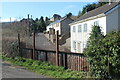
6
Harper's Road electricity substation, Garndiffaith
The cabinet is a Western Power Distribution electricity substation.
Image: © Jaggery
Taken: 19 Jul 2018
0.02 miles
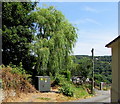
7
Harper's Road & Belvedere
Viewed from cycle track, NCR 492, on bridge over road.
Image: © M J Roscoe
Taken: 25 Feb 2022
0.04 miles
8
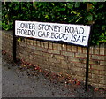
Bilingual name sign on a Garndiffaith corner
Lower Stoney Road https://www.geograph.org.uk/photo/5848108 is Ffordd Garegog Isaf in Welsh.
Image: © Jaggery
Taken: 19 Jul 2018
0.05 miles
10
Information board and signpost at Harper's Road
Cycle track, NCR 492, board on former LNWR railway at exit to Harper's Road.
Image: © M J Roscoe
Taken: 25 Feb 2022
0.05 miles