IMAGES TAKEN NEAR TO
Glen View, Stoney Road, PONTYPOOL, NP4 8QF
Introduction
This page details the photographs taken nearby to Glen View, Stoney Road, NP4 8QF by members of the Geograph project.
The Geograph project started in 2005 with the aim of publishing, organising and preserving representative images for every square kilometre of Great Britain, Ireland and the Isle of Man.

There are currently over 7.5m images from over14,400 individuals and you can help contribute to the project by visiting https://www.geograph.org.uk
Image Map
Images are licensed for reuse under creativecommons.org/licenses/by-sa/2.0
Notes
- Clicking on the map will re-center to the selected point.
- The higher the marker number, the further away the image location is from the centre of the postcode.
Image Listing (57 Images Found)
Images are licensed for reuse under creativecommons.org/licenses/by-sa/2.0
Image
Details
Distance
1
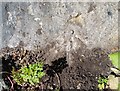
Ordnance Survey Rivet
This OS rivet can be found on the stone NW side of the road. It marks a point 242.002m above mean sea level.
Image: © Adrian Dust
Taken: 25 Aug 2019
0.02 miles
2
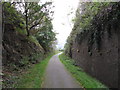
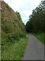
NCN Route 46 near Garndiffaith
The former Brynmawr & Blaenavon Railway, now National Cycle Network Route 46, passes in a deep cutting.
Image: © Gareth James
Taken: 15 Oct 2011
0.03 miles
3
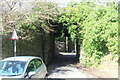
Narrow underpass below Hilvid House
The road goes under the former railway branch line and turns right to join Harper's Road.
Image: © M J Roscoe
Taken: 25 Feb 2022
0.05 miles
4
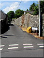
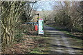
Up Stoney Road, Garndiffaith
Stoney Road ascends from Harper's Road. Lower Stoney Road https://www.geograph.org.uk/photo/5848108 is behind the camera.
The name sign near the yellow salt/grit box shows that Stoney Road is Heol Garegog in Welsh.
Image: © Jaggery
Taken: 19 Jul 2018
0.06 miles
5
Cycle track on old railway through Talywain
Image: © David Smith
Taken: 26 Sep 2021
0.07 miles
6
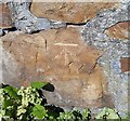
Ordnance Survey Cut Mark
This OS cut mark can be found on the wall NW side of Stanley Road. It marks a point 269.523m above mean sea level.
Image: © Adrian Dust
Taken: 25 Aug 2019
0.07 miles
7
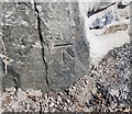
Ordnance Survey Cut Mark
This OS cut mark can be found on the stone NW side of road. It marks a point 234.446m above mean sea level.
Image: © Adrian Dust
Taken: 25 Aug 2019
0.07 miles
8
Information board and signpost at Harper's Road
Cycle track, NCR 492, board on former LNWR railway at exit to Harper's Road.
Image: © M J Roscoe
Taken: 25 Feb 2022
0.08 miles
9
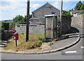
Queen Elizabeth II postbox and BT phonebox on a Garndiffaith corner
Locate here https://www.geograph.org.uk/photo/5848131 on the corner of Harper's Road and Stoney Road.
Image: © Jaggery
Taken: 19 Jul 2018
0.08 miles
10
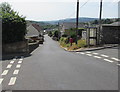
South along Harper's Road from Garndiffaith towards Abersychan
Looking past the Lower Stoney Road junction on the left and the Stoney Road junction on the right.
Image: © Jaggery
Taken: 19 Jul 2018
0.09 miles