IMAGES TAKEN NEAR TO
Lower Harpers Road, PONTYPOOL, NP4 8PW
Introduction
This page details the photographs taken nearby to Lower Harpers Road, NP4 8PW by members of the Geograph project.
The Geograph project started in 2005 with the aim of publishing, organising and preserving representative images for every square kilometre of Great Britain, Ireland and the Isle of Man.

There are currently over 7.5m images from over14,400 individuals and you can help contribute to the project by visiting https://www.geograph.org.uk
Image Map
Images are licensed for reuse under creativecommons.org/licenses/by-sa/2.0
Notes
- Clicking on the map will re-center to the selected point.
- The higher the marker number, the further away the image location is from the centre of the postcode.
Image Listing (55 Images Found)
Images are licensed for reuse under creativecommons.org/licenses/by-sa/2.0
Image
Details
Distance
1
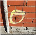
Ordnance Survey Cut Mark
This OS cut mark can be found on the School on Lower Harpers Road. It marks a point 196.752m above mean sea level.
Image: © Adrian Dust
Taken: 25 Aug 2019
0.03 miles
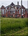
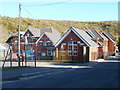
2
East side of Victoria Primary School, Abersychan
School on the corner of Lower Harper's Road and Station Street viewed in June 2024.
The school opened in May 1903 as Lower Garndiffaith Board School.
Image: © Jaggery
Taken: 23 Jun 2024
0.04 miles
3
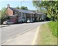
Vicarage Terrace, Abersychan
A row of eight houses on the west side of the A4043.
Image: © Jaggery
Taken: 28 Apr 2011
0.04 miles
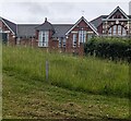
4
NE corner of Victoria Primary School, Abersychan
Viewed from Station Street across unmown grass in June 2024.
The school opened in May 1903 as Lower Garndiffaith Board School.
Image: © Jaggery
Taken: 23 Jun 2024
0.05 miles
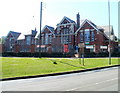
5
Victoria Primary School, Abersychan
Viewed across Lower Harper's Road. The school opened as Lower Garndiffaith Board School in May 1903.
Image: © Jaggery
Taken: 25 Oct 2010
0.05 miles
6
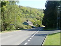
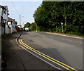
Abersychan : junction for Victoria Village and Garndiffaith
The view along Station Street (A4043) past the right turn for the hamlet of Victoria Village and the village of Garndiffaith.
Image: © Jaggery
Taken: 28 Apr 2011
0.06 miles
7
Victoria Primary School, Abersychan
The south-east side of the school, set back from Lower Harper's Road, viewed across the A4043. The school opened as Lower Garndiffaith Board School in May 1903.
Image: © Jaggery
Taken: 28 Apr 2011
0.06 miles
8
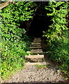
Wooden steps descending from Incline Road, Abersychan
Into woods alongside a stream, Nant Ffrwd, a tributary of the Afon Lwyd.
Image: © Jaggery
Taken: 29 Sep 2015
0.07 miles
9
Incline Road, Abersychan
From the corner of Ffrwd Road. Houses on the south side of the road are opposite woodland.
Image: © Jaggery
Taken: 29 Sep 2015
0.07 miles
10
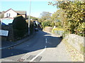
Victoria Road, Abersychan
Victoria Road heads north away from Lower Harper's Road towards Ffrwd Cottages.
On the street sign, the Welsh equivalent of Victoria is Buddug, which is also Welsh for Boadicea or Boudica.
Image: © Jaggery
Taken: 25 Oct 2010
0.08 miles